


Aggregate Surfacing Design
Standards and Guidance
This document describes the catalog method for aggregate surfacing thickness design. This method can be applied on FLH projects employing aggregate surfacing.
Exhibit 1 shows a design catalog of recommended surface aggregate layer thicknesses. Use this catalog to determine the aggregate layer thickness required for a project when more detailed information about the project is not available. The thicknesses shown are based on specific ranges of 18-kip ESAL applications at traffic levels:
| Traffic Level | 18-kip ESAL |
|---|---|
| High | 60,000 to 100,000 |
| Medium | 30,000 to 60,000 |
| Low | 10,000 to 30,000 |
Two other assumptions inherent in this thickness design are that the effective resilient modulus of the aggregate material is 30,000 psi, regardless of the quality of the roadbed soil; and there is a 0.5-inch aggregate loss per year. Exhibit 1 is from the AGDPS.
Determine the in-situ soil properties and then use Exhibit 2 and Exhibit 3 to determine the Relative Quality of Roadbed Soil.
For Soil Classification, use: ASTM Classification of Soils for Engineering Purposes (ASTM D 2487), or AASHTO Classification of Soils and Soil-Aggregate Mixtures for Highway Construction Purposes (AASHTO M 145)
For Strength of Roadbed Soil, use: Resistance Value (AASHTO T 190); California Bearing Ratio (AASHTO T 193); and/or the Resilient Modulus (AASHTO T 307)
When test results from subgrade soil are unavailable, visually estimate the Unified Soil Classification using ASTM D 2488 or other means. Then use the AASHTO and ASTM Soil Classification chart in Exhibit 2 and Roadbed Soil Strength chart in Exhibit 3 to determine the Relative Quality of Roadbed Soil.
Determine the U.S. climatic region designation from Exhibit 4. This exhibit is from the AGDPS.
Using Exhibit 1 with the appropriate Relative Quality of Roadbed Soil, traffic level, and U.S. climatic region designation, determine the minimum thickness of aggregate surfacing in inches. When a higher type of pavement design is recommended from Exhibit 1, contact the Division Pavement Engineer.
Exhibit 1 – Aggregate Surface Thickness Design Catalog
| Relative Quality of Roadbed Soil | U.S. Climatic Region | ||||||
|---|---|---|---|---|---|---|---|
| Traffic Level | I | II | III | IV | V | VI | |
| Very Good | High Medium Low | 8" 6" 4" | 10" 8" 4" | 15" 11" 6" | 7" 5" 4" | 9" 7" 4" | 15" 11" 6" |
| Good | High Medium Low | 11" 8" 4" | 12" 9" 5" | 17" 12" 7" | 10" 7" 4" | 11" 9" 5" | 17" 12" 7" |
| Fair | High Medium Low | 13" 11" 6" | 14" 11" 6" | 17" 12" 7" | 12" 10" 5" | 13" 10" 5" | 17" 12" 7" |
| Poor | High Medium Low | ^ ^ 9" | ^ ^ 10" | ^ ^ 9" | ^ 15" 8" | ^ 15" 8" | ^ ^ 9" |
| Very Poor | High Medium Low | ^ ^ 11" | ^ ^ 11" | ^ ^ 10" | ^ ^ 8" | ^ ^ 8" | ^ ^ 9" |
^ Higher type pavement design recommended.
Exhibit 2 – AASHTO and ASTM Soil Classification
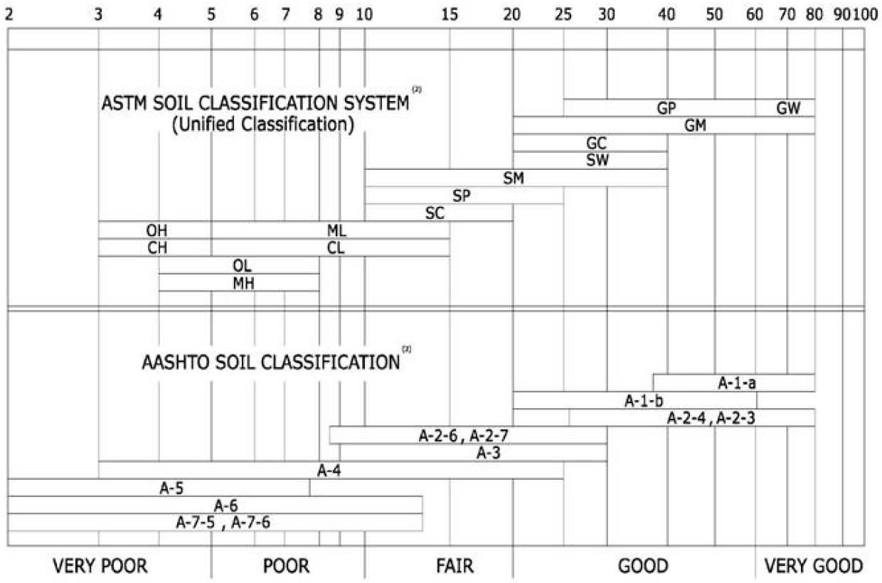
Exhibit 3 – Roadbed Soil Strength
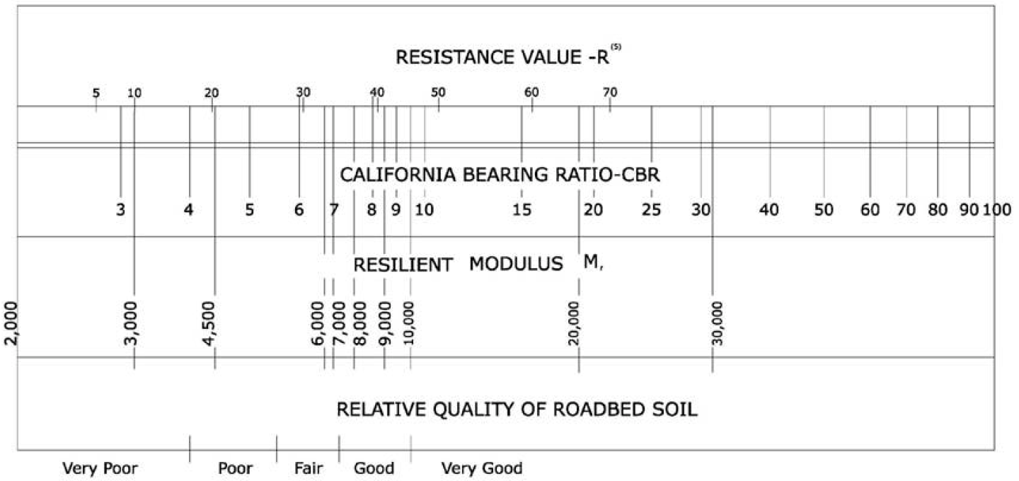
Exhibit 4 – The Six Climatic Regions in the United States
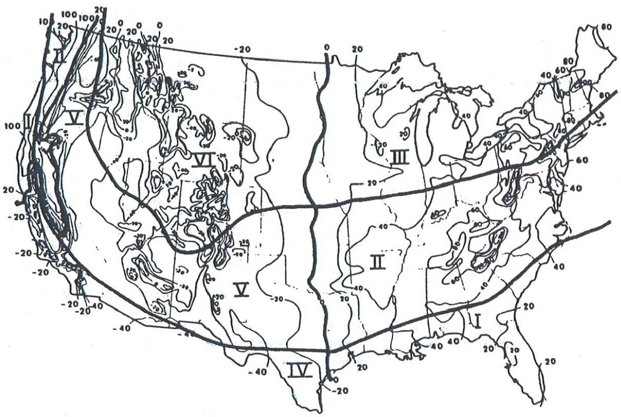
| Region | Characteristics |
|---|---|
| I | Wet, no freeze |
| II | Wet, freeze – thaw cycling |
| III | Wet, hard freeze, spring thaw |
| IV | Dry, no freeze |
| V | Dry, freeze – thaw cycling |
| VI | Dry, hard freeze, spring thaw |
Last updated: Wednesday, September 23, 2026