LIVABILITY IMPROVES AS NUMBER OF LANES DECREASES
| Objective | Features | Results |
|---|---|---|
|
|
|
LIVABILITY: Tying the quality and the location of transportation facilities to opportunities such as access to good jobs, affordable housing, quality schools and safer streets.

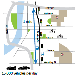
Division Street has on-street parking and signals at every intersection through downtown
BACKGROUND
The City of Grand Rapids has taken a holistic view of Road Diet implementations by identifying all 4-lane facilities within its jurisdiction, and then recording and tracking traffic volumes, corridor use, and the overall operation under existing conditions. The city recognizes the safety benefits of Road Diets and is aware of a roadway reconfiguration's potential effect on traffic operations They also recognize that Road Diets can bring a higher quality of life for users and can encourage commercial activity and sales.
This approach led the City of Grand Rapids to install a Road Diet on Division Street, from I-196 to Wealthy Street. The roadway's cross section changed from four and five vehicle lanes to three lanes and a mixture of dedicated bicycle lanes and shared lanes. Although on-street parking already existed prior to the Road Diet, the reconfiguration allowed for additional parking spots.
PUBLIC INVOLVEMENT
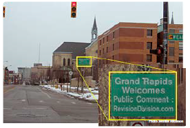
The city conducted two public meetings before this Road Diet was implemented to gain public support and to educate those who use the route. During these meetings, officials learned that citizens wanted the opportunity to try the Road Diet for a trial period and reconvene before implementing permanently.


RESULTS
After the Division Street Road Diet installation, the City of Grand Rapids reported that businesses along the corridor are generally happy with the project because of the perceived improvement in the quality of life attributes and livability of the community. A few residential facilities along Division Street that were previously unrented for 2 years have been rented after the Road Diet brought improved bicycle accessibility. The owner of those housing facilities believes that the bicycle enthusiasts who want to live along the corridor and bike to work have contributed to an overall increase in economic activity in the area.
One lesson the city learned from this project was the need to carefully evaluate the potential effects Road Diets could have on the reliability of transit schedules. Before installation, Division Street served as a local transit route. However, the bus company decided to relocate the route to another corridor after the Road Diet because of increased travel times.
Based on positive public feedback, the City of Grand Rapids ultimately chose to retain the Road Diet permanently. While the Road Diet project produced many positive outcomes, the project resulted in some negative aspects as well. The benefits and trade-offs are summarized in the following table.1
| Positive Outcomes | Trade-offs |
|---|---|
| Increased parking | Increased delay |
| Decreased vehicle speeds (-1 to -4 mph) | Longer queues (i.e., Northbound increased from 81 feet before to 180 feet after in the PM) |
| Improved bicycle facilities (bike lanes/shared lanes) | Longer travel times (average increase of 19 to 52 seconds through corridor) |
| Reduction in head-on left turn (-38%)*, angle (-17%), and sideswipe crashes (-20%) | Rear-end crashes nearly tripled after installation |
| Increased pedestrian/bicycle flow (+13% PM, +57% off-peak, and -14% AM) | Increased emissions (+19.8% AM, +1.1% off-peak, and -5.3% PM) |
| Decreased volumes (-18% to -29% north of Wealthy St.) | Diversion from the corridor |
| *Calculated from data in the referenced Report (eight crashes before to five crashes after; this percentage varies from the percentage published in the report table. | |
1City of Grand Rapids, Michigan, "Revision Division Road Diet Traffic Impact Study: Final Report," February 2013.
