
ROAD DIET IMPROVES SAFETY FOR MOTORIZED AND NON-MOTORIZED USERS
| Objective | Features | Results |
|---|---|---|
|
|
|
 |
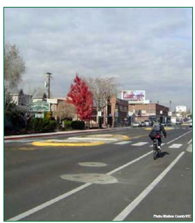 Wells Avenue after the completion of the Road Diet. |
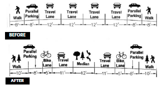
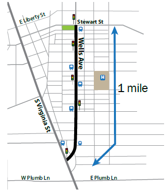
In 2003, the Regional Transportation Commission (RTC) of Washoe County installed a Road Diet on Wells Avenue between Stewart Street and South Virginia Street in Reno, Nevada. This section of Wells Avenue spans mostly commercial property. The original 4-lane cross section of Wells Avenue was converted to one vehicle lane in each direction, a center turn lane, a dedicated bicycle lane on each side, and wider sidewalks. The modification maintained the existing on-street parking on the corridor.
IMPLEMENTATION PLAN
The Road Diet on Wells Avenue was completed as a part of the RTC's Complete Streets initiative. The reconfiguration allowed for the addition of bicycle lanes and designated parking lanes, and the design integrated safety features such as curb extensions, frequent crossing opportunities, medians, pedestrian refuge islands, and lighting. To improve the aesthetics and livability of the corridor, the RTC also incorporated landscaping, benches, and public art into the project.
RESULTS
Two years after the completion of the Road Diet along Wells Avenue, the RTC reported the reductions in crashes were most evident in rear-end, angle, and overtaking sideswipe crashes, which were the most common crash types prior to the modifications. The Road Diet is also credited with reducing the number of pedestrian crashes by 54 percent.
| Crash Type | Before | After |
|---|---|---|
| Angle | 33 | 19 |
| Pedestrian | 13 | 6 |
| Rear End | 52 | 43 |
| Sideswipe, Overtaking | 13 | 4 |
| Head On | 0 | 2 |
| Sideswipe, Meeting | 0 | 3 |
| Rear-to-rear | 0 | 1 |
| Backing | 0 | 2 |
| Unknown | 12 | 5 |
| TOTAL | 123 | 85 |
After the Road Diet, average traffic speeds had decreased between 5 and 9 miles per hour (14-24 percent reduction).
Pedestrian crashes have been reduced by 54%
The roadway segment also experienced an approximate 10 percent drop in traffic volume (from 15,854 to 14,244 vehicles/day). Although RTC has not confirmed that the traffic has shifted to parallel streets, this sometimes occurs when a road undergoes a Road Diet.
The RTC reported no change to the road's level of service after the Road Diet implementation. The RTC speculates that this is likely due to the existence of exclusive left-turn lanes at signalized intersections. At unsignalized intersections, the exclusive two-lane left-turn lane provides improved service to main street left-turn and side street left-turn traffic.
Source: The Regional Transportation Commission of Washoe County, "Wells Avenue Traffic Study, Four-to-Three Lane Conversion, Final Report," June 1, 2008. Accessed March 23, 2015. Available at: http://www.westofwells.com/PDImages/docs2/WellsStudy%20Final.pdf