
DESPITE EARLY OPPOSITION, ROAD DIET PRODUCES GREAT RESULTS
| Objective | Features | Results |
|---|---|---|
|
|
|
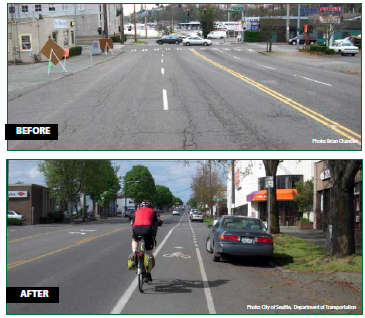
As part of a repaving project in 2007, Seattle Department of Transportation (SDOT) completed a Road Diet on Stone Way from 34th Street to 45th Street. It was the twenty-third lane reduction project undertaken by the city since 1972. Along with implementing the Stone Way Road Diet, the city also adopted a Bicycle Master Plan, which aimed to make Seattle the best community for bicycling in the United States.1 The Stone Way conversion supported this new initiative by adding bicycle lanes.
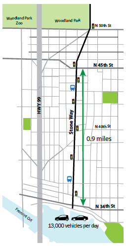
Connecting the Fremont and Wallingford neighborhoods in Seattle, Stone Way is a north-south arterial that carries approximately 13,000 vehicles per day and numerous Metro bus routes. There are many pedestrian generators in the area including parks, a trail, the Woodland Park Zoo, and several schools.
 |
 |
| The Stone Way Road Diet improved pedestrian and bicycle safety by incorporating pedestrian refuge islands and a combination of shared lanes and bicycle lanes. | |
OPPOSITION AND SUPPORTERS
Although the residents in Seattle were not strangers to Road Diets, there remained some strong opposition to the proposed Stone Way reconfiguration. Local business owners felt Stone Way is a vital arterial and should not be changed. "We need the road. We need to move traffic, particularly trucks. It's not a good idea to narrow the street down because traffic will overflow on other streets. This is our arterial. We want the four lanes of traffic."2
On the other hand, the bicycle activist community in Seattle vigorously supported the implementation of the project by organizing traffic counts, a demonstration ride, and commissioning an outside consultant report that asserted that undue congestion would not occur.3
RESULTS
In 2010, SDOT completed a before-and-after study to evaluate the effects of the Stone Way Road Diet. The results are as follows:4
- Top-end speeders reduced. Top speeders (those traveling more than 10 mph over the speed limit) decreased by more than 80 percent.
- Collisions reduced. Total collisions were reduced by 14 percent and injury collisions decreased by 33 percent.
- Pedestrian crossings are safer. Pedestrian collisions were reduced by 80 percent.
- Bicycle volume has increased. The volume of bicyclists increased 35 percent from 2007 to 2010.
- Motor vehicle traffic has not diverted to neighborhood streets. Daily traffic counts on parallel streets are down by 12 to 34 percent, which is a greater decrease than the slight decline of 6 percent recorded on Stone Way.
- Peak hour capacity has been maintained. The study confirmed the corridor has sustained its capacity to carry the same number of motor vehicles in spite of the reduction in the number of travel lanes.
1 City of Seattle, "Seattle Bicycle Master Plan," 2007.
2 S. Gilmore, "City Wants to Put Four-Lane Stone Way on Road Diet" The Seattle Times, October 12, 2006. Accessed March 23, 2015. Available at: http://www.seattletimes.com/seattle-news/city-wants-to-put-four-lane-stone-way-on-road-diet/
3 S. Ullman, "Stone Way: 1 of 34 Rightsizing Projects Making Seattle Safer and More Livable" Project for Public Spaces. Accessed March 23, 2015. Available at: http://www.pps.org/reference/stone-way-one-of-34-rightsizing-projects-making-seattle-safer-and-more-livable/
4 "Stone Way N Rechannelization: Before and After Study, N 34th Street to N 50th Street," City of Seattle Department of Transportation, May 2010