
ROAD DIET IMPROVES MULTIMODAL LEVEL OF SERVICE
| Objective | Features | Results |
|---|---|---|
|
|
|
 |
 |
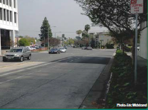
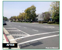 Cordova St at Chester Ave looking west |
BACKGROUND
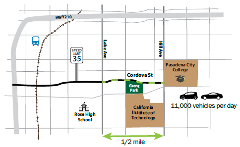
With the intent to reduce speeds and improve safety, the City of Pasadena completed a Road Diet in June 2010 on Cordova Street in conjunction with a repaving project. In support of the city's Bicycle Master Plan, the project spanned just over one-half mile, from Lake Avenue to Hill Avenue and provided bicycle lanes along the corridor.
Located adjacent to the Central Business district, Cordova Street includes multi-family residential and commercial property and is home to a private school, park, and community college along the Road Diet corridor. Cordova Street carries approximately 11,000 vehicles per day, with AM and PM peak hour traffic volumes varying between 600 and 1,000 vehicles.
 Cordova St. looking east |
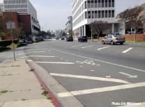 Cordova St at Mentor Ave looking west toward Lake Ave |
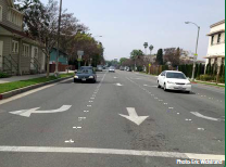 Cordova St at Hill Ave cross section |
PLANNING AND OUTREACH
MULTIMODAL LEVEL OF SERVICE: Analysis that assesses how well a street serves the needs of all users.
Using funds from the American Recovery and Reinvestment Act, a basic repaving project planned for Cordova Street allowed for the Road Diet conversion and helped fulfill the city's goal of installing bicycle lanes and enhancing existing curb parking along this corridor.
The City of Pasadena conducted outreach through the city council's office and the city's website prior to beginning the transformation.
"Pasadena is always looking for new ways to provide non-vehicular alternative modes of travel to its citizens," said city Transportation Director Fred Dock. "This project will serve the bicyclists traveling between the South Lake District and Pasadena City College, making it safer for pedestrians to cross at intersections and potentially reducing the driving speed of motorists."1
The city's analysis followed the guidelines presented in NCHRP Report 616 Multimodal Level of Service Analysis for Urban Streets.
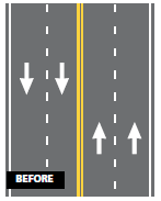
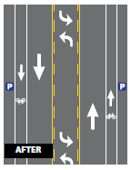
Preceding this project, there had been some speeding issues on Cordova Street, and because of safety concerns residents had requested the installation of additional traffic signals to help pedestrians cross the street. The Road Diet was able to benefit pedestrians without installing new traffic signals by removing two through lanes of traffic and adding painted curb extensions at intersections, providing ample opportunities to cross at unsignalized intersections along the corridor.
RESULTS
A before-and-after study completed in late 2011 examined traffic speeds, volumes, safety, and the multimodal level of service. The results showed an improved bicycle level of service and no changes to pedestrian or vehicular levels of service along the corridor. There was also a slight reduction in total collisions and injuries. After the Road Diet, traffic speeds were reduced and compliance with the posted speed limit increased.
1 The City of Pasadena, "Cordova Street To Be Placed On A Road Diet," June 14, 2010. Accessed March 17, 2015. Available at: http://www.ci.pasadena.ca.us/EkContent.aspx?theme=Navy&id=8589935066&bid=2970&style=news