
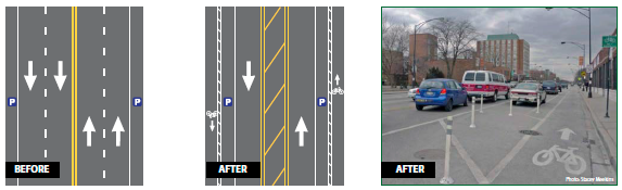
ROAD DIET INCLUDES PARKING-SEPARATED BICYCLE LANES
| Objective | Features | Results |
|---|---|---|
|
|
|
BACKGROUND
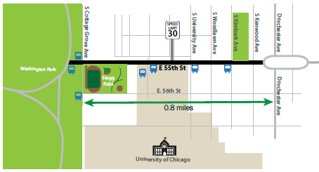
In 2011, an announcement from Chicago's mayor that the city would install 100 miles of separated bicycle lanes was the starting point that led to the Road Diet on 55th Street. From Cottage Grove Avenue to Dorchester Avenue, this 0.8-mile segment of roadway runs along the University of Chicago campus and ends on the west end at Washington Park. This Road Diet transformed a 4-lane roadway with parking on both sides to a 3-lane roadway with parking-separated bicycle lanes. The land use along 55th Street is primarily a mix of institutional, residential, commercial, and service uses, including a fire station.
The University of Chicago buildings and athletic fields abut 55th Street on one side, and a service drive parallels a portion of this corridor.
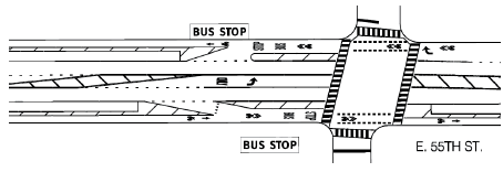
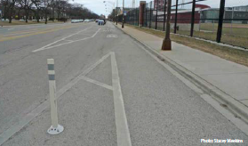 Bus Entry |
 Bus stop and shared lane at intersection, through intersection markings |
DESIGNING FOR BUS STOPS AND SEPARATED BICYCLE LANES
The Chicago Transit Authority (CTA) has a primary bus route along this corridor, with headways ranging from 5 to 20 minutes throughout the day. The city coordinated extensively with the CTA on the design of the Road Diet. The overall design and layout of the bus stops in coordination with the separated bicycle lanes was a critical issue to maintain efficient bus operation.
The addition of bicycle lanes is a great advantage to university of Chicago students, staff, and visitors
RESULTS
The 55th Street Road Diet experienced the following results after installation.
- Speeding had been an issue on the corridor prior to the Road Diet, but since the conversion, drivers have been closely adhering to the 30 mph speed limit.
- One business owner was concerned about losing on-street parking spaces, but overall he felt that cars were driving slower now and he saw the bicycle lane as an important addition.
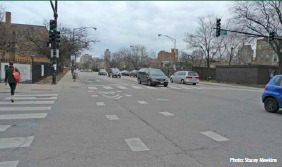
- According to a city engineer, the Road Diet has made it easier for pedestrians to cross 55th Street at intersecting roadways.
- The community expressed that the Road Diet has benefited livability. Since 55th Street runs along the University of Chicago campus, the addition of bicycle lanes was a great advantage to students, staff, and visitors.