EDUCATING THE PUBLIC ON ROAD DIETS
| Objective | Features | Results |
|---|---|---|
|
|
|
BACKGROUND
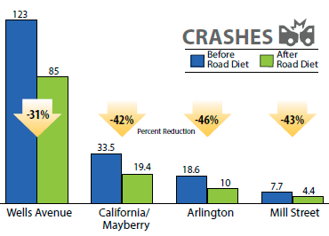
The Regional Transportation Commission (RTC) of Washoe County has implemented many Road Diets within the City of Reno to allow for the addition of bicycle lanes. These projects were created as part of the Complete Street initiative to stimulate economic development and improve citizens' quality of life. The RTC has been proactive in educating the public during the entire process of implementing Road Diets. Once projects are complete, the RTC also publicizes the annualized crash rates1 for the road segments which have undergone the Road Diet treatment. This increases the public's understanding of the safety benefits.
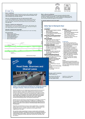
The flyer provides answers to the most frequently asked questions:
- What is a Road Diet?
- How can a road with fewer lanes carry the same amount of traffic?
- How does a Road Diet make walking safer?
- How does a Road Diet making bicycling safer?
- Road Diet benefits
- What is a shared lane marking?
- Are bicycles supposed to move to the right?
- If I see these markings in a lane, is the lane only for bicycles?
The Road Diet provides opportunities to increase on-street parking, which benefits motorists and businesses. The safety and improved flow are especially beneficial on roads like California and Arlington with lots of driveways and side streets. Moving the people making turns out of the traffic stream improves flow and reduces rear end collisions.
Excerpt from RTC's public outreach flyer, Road Diets, Sharrows and Shared Lanes

The RTC also publicizes the annualized crash rates1 for the road segments which have undergone the Road Diet treatment. This increases the public's understanding of the safety benefits.
In an effort to promote safety, the flyer provides additional safety tips for bicyclists and motorists as they adjust to sharing the same lanes. These tips include reminding bicyclists that they are required to obey traffic laws and traffic control devices and encouraging them to ride predictably and to consider when drivers may or may not see them (e.g., passing traffic on the right-hand side or entering intersections when a driver's view may be obstructed). Other safety tips include suggesting motorists leave 3 feet of lateral space when passing a bicyclist, being aware of bicyclists when turning right across a bicycle lane, and checking for bicyclists before opening car doors on street-side parking.
RESULTS
The RTC's approach to Road Diet public education and outreach has been a key component in the success of their projects and has allowed them to continue to implement Road Diet treatments in Reno.
 |
|
|
Experimenting with green-colored pavement in a continuous, longitudinal manner in conjunction with the shared-lane marking remains discontinued at this time. More information on the FHWA's active official experiments for green-colored pavement to communicate a continuous, longitudinal direction in conjunction with shared-lane markings can be found at the following websites: https://www.fhwa.dot.gov/environment/bicycle_pedestrian/guidance/design_guidance/ mutcd/ gcp_slm.cfm and the MUTCD Official Rulings Database at http://mutcd.fhwa.dot.gov/orsearch.asp |
|
1 These crash rates are based on before-and-after studies of four Washoe County Road Diet locations. The numbers of crashes have been annualized to show a direct comparison between the locations. The percentages are intended for informational purposes only.
