ROAD DIET IMPROVES SAFETY NEAR SCHOOL
| Objective | Features | Results |
|---|---|---|
|
|
|


BACKGROUND
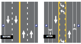
The City of Santa Monica installed an interim Road Diet on Ocean Park Boulevard in 2008 with hopes of improving safety for pedestrians and bicyclists in the area. Extending 1.1 miles, from Lincoln Boulevard to Cloverfield Boulevard, the Road Diet included restriping, bicycle lanes, and on-street parking. The corridor is a transit route and carries approximately 23,000 vehicles per day, the upper end of traffic volumes typically recommended for a 3-lane Road Diet. The land use along Ocean Park Boulevard includes several schools and a neighborhood commercial district. The speed limit on the corridor is 35 mph, with a school zone area of 25 mph when children are present.
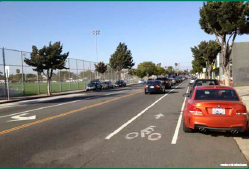
 Ocean Park Boulevard looking east at 16th Street |
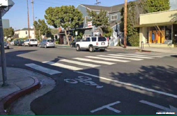
 Ocean Park Boulevard looking east at 18th Street marked crosswalk and bicycle lane |
SAFETY ISSUES
The main focus area of the Ocean Park Boulevard Road Diet was a short segment from 16th Street to 18th Street, which includes the Will Rogers Elementary School, the John Adams Middle School, and recreational facilities. With such a high volume of student activity in this area, vehicle speeds and a recent increase in crashes were concerning for parents, school faculty, and nearby residents. It became apparent to city officials that additional safety improvements were necessary since previous efforts such as adding crossing guards, flashing crosswalks, and speed feedback signs had little influence on speeding and the number of crashes.1
This road diet configuration resulted in a 65% reduction in collisions.
RESULTS
In the first 9 months following the reconfiguration, collision data indicated there was a 65 percent reduction (from 35 to 12 crashes), as compared to the same 9-month period in the year prior to the Road Diet installation. Injury collisions were reduced by 60 percent following the reconfiguration.
Travel speeds, based on statistics from the local transit provider in the corridor, have generally remained constant throughout the day. The 85th percentile speed within the Road Diet is at or below 27 mph, and speeds are approximately 10 mph higher outside the Road Diet limits. Utilizing a survey available online and distributed by mail, the city gauged the community's sentiment on the Road Diet installation. Many people appreciated the improved conditions for bicyclists and pedestrians, but others were dissatisfied by delays and a perception that the reconfiguration caused motorists to shift onto parallel streets.
The city collected traffic counts on Ocean Park Boulevard and the nearby roadways. Volumes on Ocean Park Boulevard decreased by approximately 3,000-4,500 vehicles per day after the conversion. The city's analysis was inconclusive on where these trips shifted. Some of the vehicles appeared to move to I-10 Freeway, but traffic counts showed the volumes on nearby local streets have been relatively stable.
Because of the resulting safety improvements and reduction of speed, the city made the decision in 2010 to retain the Road Diet configuration permanently as part of a resurfacing project along Ocean Park Boulevard.
1 Ashley Archibald, "Ocean Park Blvd. Lane Change Project Made Permanent" Santa Monica Daily Press, April 12, 2011. Assessed March 17, 2015. Available at: http://smdp.com/ocean-park-blvd-lane-change-project-made-permanent/78451
