
This section describes the process for integrating RSAs in the planning process, including potential partners, implementing RSA findings, and potential challenges.
Who Should I Partner With to Integrate an RSA Program in the Planning Process?
Many of the same partners identified to assemble an RSA team are the same partners that can assist in integrating an RSA program into the planning process. For example, the Office of Federal Lands Highway provides “program stewardship and transportation engineering services for planning, design, construction, and rehabilitation of the highways and bridges that provide access to and through Federally-owned lands.” FLH consists of the following: Eastern, Central, and Western Federal Lands Highway Divisions as well as the Headquarters office. These units of the FLH work with Tribes, FLMAs, and States to address and improve safety. FHWA’s Division Office in each state is also a resourceful partnering agency.
RSAs on Federal and Tribal Lands often require unique partnerships to assess safety. These partnerships can be critical in incorporating long-term suggestions or establishing a long-term RSA program.
State DOTs, MPOs, and COGs are also open to forming partnerships with Federal and Tribal land agencies. Several DOTs have internal departments devoted specifically to setting up partnerships between agencies. Federal and Tribal land agencies also have formed committees and councils to communicate their needs to DOTs, MPOs, and COGs. By working together, agencies have realized the benefits of cooperative participation where the needs and concerns of all parties involved can be voiced and addressed in a timely and efficient manner.
Case Study
In Arizona, coordination and information sharing between the Arizona Department of Transportation (ADOT) and the Inter Tribal Council of Arizona, Inc. (ITCA) have advanced consultation activities between ADOT and tribal governments in transportation planning efforts. The partnering between ADOT and the ITCA has (1) provided insight to ADOT staff of the challenges facing tribes throughout the state, and (2) increased awareness amongst tribal transportation staff of the opportunities for input into state-level transportation planning efforts. Besides the ITCA, ADOT has formed partnerships with other agencies: Arizona State Land Department, Arizona Tribal Strategic Partnering Team, Bureau of Land Management, the United States Forest Service, and FHWA. These partnerships have helped effectively streamline tribal transportation consultation in Arizona. In an effort to assist tribal governments and tribal planning departments in understanding the ADOT transportation planning and programming processes, ADOT has developed Transportation Planning and Programming – Guidebook for Tribal Governments.
The Arizona Tribal Transportation website (http://www.aztribaltransportation.org/) provides a wealth of information with regard to state-tribal transportation related partnerships, projects, activities, and funding resources. Other helpful information can be found on ADOT’s partnering office website and on the ITCA website.
Case Study
The Wisconsin Department of Transportation (WisDOT) has formed a formal partnership with the State’s Federally-recognized Tribes. The Wisconsin State Tribal Relations Initiative recognizes the government-to-government relationship between the State and Tribal governments. As such, the State-Tribal Consultation Initiative is poised at improving communication between State and Tribal representatives to ensure that concerns and issues are addressed in a timely and efficient manner. This partnership is applied through the WisDOT Tribal Task Force. Since 2008, the task force has provided funding for the Tribes to conduct RSAs. Many of the RSAs were targeted at Reservations where WisDOT was planning roadway improvements.
How Do I Incorporate RSA Findings in the Planning Process?
Step 8 of the RSA process introduced in Chapter 1 involves the implementation of safety improvement measures identified by the RSA team. Incorporating RSA findings into the planning process is largely dependent on the desired timeframe for implementation (i.e., short-, intermediate-, or long-term). Short-term improvements (e.g., signing, pavement markings, and vegetation control) can often be handled through maintenance activities. Intermediate- and long-term improvements (e.g., updating/installing guardrail, installing a shared use path, realigning/widening, etc.) can be integrated into local, regional, and State transportation improvement programs and plans. It is important for all parties involved in the RSA process to understand the intent and extent of these programs as they pertain to the area being studied so that safety issues may be addressed in an appropriate timeframe.
Transportation agencies are charged with developing long-range plans for the transportation systems on State, Tribal, and Federal lands. Examples include the Transportation Improvement Program (TIP), Statewide Transportation Improvement Program (STIP), Tribal Transportation Improvement Program (TTIP), Comprehensive Conservation Plan (CCP), and General Management Plan (GMP). A major component of these plans is a comprehensive transportation study which identifies short- and long-term needs. The findings on an RSA are important to fully addressing these needs.
A brief description of the identified programs and plans is provided. For specific information regarding the long-range plans in your area, contact your State DOT, Tribal DOT, or FLH. Figure 3 illustrates how RSAs contribute to the overall planning process.
- Transportation Improvement Program (TIP): The TIP is a regional prioritized, fiscally-constrained, and multi-year list of Federally-funded, multimodal transportation projects. Specifically, the TIP covers at least a four-year program of projects and is updated every few years. Projects in the TIP are prioritized at the regional level and have clearly identified funding sources. The TIP represents an agency's intent to construct or implement a specific project and the anticipated flow of Federal funds and matching State or local contributions. The TIP is incorporated in the Statewide Transportation Improvement Program (STIP).
- Statewide Transportation Improvement Program (STIP): The STIP is a financially-constrained list of transportation projects consistent with the State long-range transportation plan and other regional plans. The STIP includes all capital and noncapital projects that are targeted to use Federal Highway Administration or Federal Transit Administration (FTA) funds. The STIP also includes all regional TIPs and the portion of the Indian Reservation Roads, Forest Service, Fish and Wildlife Service, or National Park Service TIP applicable to that State.
- Tribal Transportation Improvement Program (TTIP): The TTIP is similar to the TIP, but is the list of Tribal transportation projects to be funded in the next few years. The TTIP is a list of proposed transportation projects developed by a Tribe based on the Tribal priority list or the long-range transportation plan. The TTIP contains all projects funded by the IRR program and scheduled for construction in the next three to five years. It also includes other Federal, State, county, and municipal transportation projects initiated by or developed in cooperation with the Tribal government. For more information on developing a TTIP, refer to Developing the Tribal Transportation Improvement Program (FHWA-HEP-08-003) available online.
- Comprehensive Conservation Plan (CCP): A CCP is required by law for all lands within the National Wildlife Refuge System. A CCP is a document that provides a comprehensive framework for guiding refuge management decisions. The National Environmental Protection Agency (NEPA) requires CCPs to examine a full range of alternative approaches to refuge management. CCPs are also intended to encourage public involvement in selecting alternatives that are best suited to a refuge’s purposes. Refuge transportation studies have been used to develop the transportation component of CCPs. These studies have examined the core transportation network within a refuge, identifying short- and long-term transportation, capital, and maintenance plans for future programming.
- General Management Plan (GMP): A GMP is the National Park Service’s version of the CCP (see description above).
- USDA Forest Service Strategic Plan: The plan provides strategic direction to the Forest Service’s commitment to its mission. The programs and budget are aligned to meet the goals and objectives contained within the plan. Through this programming, the Forest Service is capable of providing financial and technical assistance in collaborative efforts with States, Tribes, local communities, and other partner agencies. One component of the plan is the condition of the transportation infrastructure, including off-highway vehicle access.
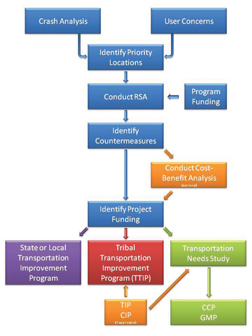
Figure 4 : RSAs in the Planning Process
What Challenges Will I Face and How Do I Overcome These Challenges?
Much like the challenges faced when establishing an RSA program, similar challenges may be realized when incorporating an RSA program into the planning process. Identifying appropriate partners and obtaining funding is described in Chapter 3. Other challenges include the availability of data and jurisdictional boundaries.
Data Quantity and Quality – For many RSAs conducted on Federal and Tribal lands, the lack of data and/or the poor quality of available data are issues when identifying and prioritizing locations. In many instances, crashes are not formally documented. When documents have been prepared, the data may be incomplete or inaccurate. These data constraints do not help pinpoint locations in need of attention or provide a good understanding of the safety hazards, thus making it difficult to program appropriate measures into transportation improvement plans.
Case Study
An RSA conducted on the Savannah National Wildlife Refuge study area revealed that many run-off-the- road crashes were not reported as a result of the location of the crash. Vehicles involved in run-off-the-road crashes along a State roadway going through the refuge were not represented in the crash reports; once the vehicle leaves the roadway it enters Federal refuge property. The motorist is responsible for removing the vehicle and it is not reported by the police.
The lack of data and/or the poor quality of available data can be overcome by using alternative methods for identifying and prioritizing locations for RSAs. Consulting with local law enforcement, emergency medical services, health services, and/or the public can help with the identification of common issues and problematic locations that could be considered as potential candidates for an RSA. Law enforcement and public input provides anecdotal information that often helps create a more complete picture of potential hazards even without quantifiable data. The inputs to the process can be a combination of objective and subject measures depending on the availability, quality, and detail of the data (see Chapter 2).
Jurisdictional Boundaries – Ownership of facilities or projects involving Federal or Tribal lands can be unique. For example, an RSA may be conducted on a state-owned roadway that travels through or adjacent to a Federal land. In other cases, local agencies such as counties, townships, and villages may also have roadway jurisdiction. When a facility or project is under multiple jurisdictions, there are multiple interests that are involved. One challenge is to ensure that all parties affected by programs or initiatives are well informed and that concerns are received and addressed appropriately. Another challenge is to determine which jurisdiction is responsible for planning and implementing changes, performing maintenance activities, providing enforcement, and keeping up-to-date records. This can become particularly difficult when multiple agencies are involved, especially when staffing and financial responsibility must be assigned. It is important to realize, though, that while the ownership of a facility or project can be very complex and present difficult challenges, there are also benefits of multi-agency involvement. For example, funding for reconstruction and maintenance may be limited for an individual agency, but options can be identified for pooling resources to implement suggested RSA improvements.
Case Study
An RSA for the Navajo Nation was conducted along N-35. The portion of the N-35 corridor studied is a Federal Aid Highway. A portion of the roadway (milepost 0 to 18) is owned by the Bureau of Indian Affairs. The Phillips Oil Company paved a section of N-35 (milepost 18 to 23), but road ownership remains with the Navajo Nation. Funding for reconstruction and maintenance of N-35 comes from several sources, including the Indian Reservation Roads Program, Congressional earmarks, and the BIA road maintenance program. The funding for road improvements is administered by the Navajo Region Division of Transportation (NRDOT) through the IRR Program within the Federal Lands Highway Program. Funding for road maintenance comes from the Department of the Interior (DOI) and is also administered by the NRDOT. They have contracted San Juan County to maintain much of the roads in the county, including N-35. San Juan County is responsible for signing, pavement markings, and roadside mowing.
Effective communication between all parties in the RSA process is important to overcome jurisdictional boundaries. It is also important to understand how the RSA process and the resulting suggestions for improvement fit into the planning process for each agency, region, and/or State. Through partnerships, many DOTs have created formal initiatives with FLMAs and Tribes to ensure that each agency’s interests are addressed through the planning process while minimizing negative impacts or feelings by any party involved (see “Who should I partner with to integrate an RSA program in the planning process?”). It is also important that other local and regional stakeholders (e.g., MPOs and COGs) buy into the RSA process and realize the benefits of the suggested improvements so that the program gains support, relationships form and grow, and measures continue to be programmed.