CASE STUDY RSAs
RSA NUMBER 1
STANDING ROCK SIOUX TRIBE (NORTH AND SOUTH DAKOTA): RSA OF RESERVATION ROADS
| Roads:existing two-lane rural tribal roads | |
|---|---|
| RSA Sites: |
|
| Environment: |  urban/urbanized urban/urbanized  suburban suburban  rural rural |
| Owners: | Standing Rock Sioux Tribe, Bureau of Indian Affairs (BIA), North Dakota DOT, South Dakota DOT |
| Road Safety Audit | |
|---|---|
| Date of RSA: | 22-24 May 2005 |
| RSA Stage(s): |  planning/design stage planning/design stage  RSA of existing roads RSA of existing roads |
| RSA Team: | staff from the Standing Rock Sioux Tribe, Federal Highway Administration (North Dakota and South Dakota field offices), North Dakota DOT, South Dakota DOT, Bureau of Indian Affairs, North Dakota State University, Northern Plains TTAP, and Opus Hamilton |
BACKGROUND:
The Standing Rock Sioux Tribe (SRST) reservation in North and South Dakota extends over 2.3 million acres, with an extensive rural road network of BIA, county, and state roads. The reservation roads connect the reservation's communities to each other and to the tribal administrative center in Fort Yates, ND. They also serve through traffic, and provide access to the Tribe's two casinos.
At the time of the RSA, the Standing Rock Sioux Tribe was actively pursuing improvements to transportation infrastructure on the reservation. Under the SRST Transportation Department, the Tribe had embarked on a long-range, multi-million-dollar program to upgrade community transportation facilities, using an innovative financing scheme involving government, tribal, and borrowed funds.
The Tribe maintained its extensive road network using its own funds as well as funding from sources such as the BIA. Maintenance of tribal roads was a sensitive topic, since funding for maintenance involved an extensive government allocation effort that limited the amounts available to reservations. At the same time, road maintenance was viewed as an important responsibility that directly affected tribal efforts to build a cohesive reservation community and promote economic activity. Maintenance of the roads on the SRST reservation was a challenge due to their extent (connecting a population of about 9,000 spread over 850,000 acres) and the impacts of the Northern Plains environment (winter road conditions, frost damage, and variations in the underlying water table). Although the SRST reported that it fully utilized available government funds and its own funds, the RSA team observed multiple maintenance-related issues on reservation roads, which are summarized as Issue 1 in Table A.1.
Roads studied during this RSA included ND 24 and Highway 1806 (part of BIA 3), US 12, and community access roads. Typical reservation roadways are shown in Figure A.1. The RSA team drove these roads to identify safety issues associated with road geometry, traffic operations, and maintenance. Although bridge inspection is not a usual part of the RSA process, the RSA team was asked to observe possible maintenance issues associated with a bridge on BIA 3 at Four-Mile Creek. RSA findings associated with the bridge were included in the RSA report.
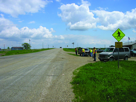
BIA 3 at intersection with ND 24 South of Fort Yates, ND
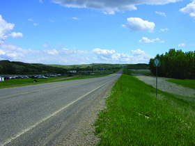
BIA 3 / Hwy 1806 in Kenel, SD
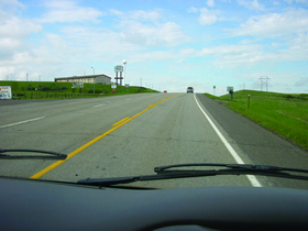
US 12 at Grand River Casino (left), near Mobridge, SD
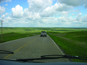
BIA 44 west of Mahto, SD
FIGURE A.1 VIEWS OF RSA SITES (STANDING ROCK SIOUX TRIBE RSA)
KEY RSA FINDINGS AND SUGGESTIONS:
The key findings and suggestions of the RSA are summarized in Table A.1.
| SELECTED SAFETY ISSUE (Number and Description) | RISK RATING | SUGGESTIONS | |
|---|---|---|---|
| 1 | Road Maintenance: Limited maintenance on reservation roads contributes to poor pavement conditions and concern regarding bridge stability. | B to D |
|
| 2 | Access to Grand River Casino: Drivers turning into and out of the Grand River Casino may interfere with crossing, opposing, and following traffic on US12. | D |
|
| 3 | BIA 31 and ND 24 (School Frontage): Driver workload is potentially high near the intersection of BIA 31 and ND 24, which accommodates local, school, and through traffic. | B to D |
|
| 4 | BIA 3 and Highway 1806 (Kenel): Vehicle and pedestrian traffic may interfere with through traffic on BIA 3 through Kenel. | B to D |
|
| 5 | Hwy 1806 and US 12 (Jed's Landing): Driver workload is potentially high at the intersection, which accommodates high turning volumes and high speeds. | C |
|
| 6 | BIA 3 and ND 24: Left-turning vehicles may obstruct through vehicles at highway intersection on a horizontal curve. | A |
|
KEY LESSONS LEARNED:
This large RSA team effectively combined members from a wide range of disciplines and jurisdictions, and included experts with relevant specialist knowledge. The core disciplines that must be represented on any RSA team are traffic operations, geometric design, and road safety. Beyond these core requirements, the Standing Rock RSA team included members with a range of backgrounds and specialties, including team members from the Standing Rock Sioux tribe, two state DOTs having highways traversing the reservation, two state FHWA field offices, the Bureau of Indian Affairs, the Northern Plains Tribal Transportation Assistance Program (TTAP) program, and North Dakota State University. The RSA team members contributed a wealth of knowledge and expertise in topics as diverse as pedestrian safety, pavement maintenance, and tribal policies, practices, and conditions.
See also the discussion of "Key Factors for Success" and "Lessons Learned" in the main text.
RSA NUMBER 2
SANTA CLARA PUEBLO: RSA OF STATE HIGHWAY NM 30 THROUGH THE PUEBLO
| Road: existing two-lane rural tribal road | |
|---|---|
| RSA Sites: |
|
| Project environment: |  urban/urbanized urban/urbanized  suburban suburban  rural rural |
| Project Owner: | Santa Clara Pueblo and New Mexico Department of Transportation |
| Road Safety Audit | |
|---|---|
| Date of RSA: | 24-25 October 2006 |
| RSA Stage(s): |  planning/design stage planning/design stage  In-service audit In-service audit |
| RSA Team: | staff from Santa Clara Pueblo, Bureau of Indian Affairs (BIA) Southwest Regional Office, New Mexico DOT (District 5), Federal Highway Administration, Gannett Fleming West Consultants, Opus Hamilton, VHB |
BACKGROUND:
The Santa Clara Pueblo in New Mexico is home to approximately 11,000 residents. State Highway 30 (NM 30), which runs through the Pueblo, has an estimated AADT of 9,000 vehicles, reflecting use by:
- Residents of the Pueblo for travel within Pueblo lands, as well as travel to neighboring communities.
- Visitors to the Pueblo and its attractions, including the Black Mesa Golf Club, scenic Santa Clara Canyon, and historic Puye Cliff Dwellings.
- Through traffic on NM 30, including commuters travelling between Los Alamos (an employment center south of the Pueblo) and Espanola (a residential area north of the Pueblo).
The highway accommodates a substantial truck volume, estimated at 16 percent of AADT. Posted speed limits along the audit segment vary from 45 to 60 mph, with a 15 mph speed limit posted at a school crosswalk for two hours on school days. Two views of NM 30 are shown in Figure A.2.
The main residential area of the Pueblo is divided by the NM 30, which separates the historic center of the Pueblo on the east side of the highway from more recently-developed residential areas on the west side. The Pueblo's transportation agency has very effectively limited vehicle access to the highway by designating a limited number of access points and restricting, where possible, direct driveway access. Similarly, it encourages pedestrians to cross the highway in a safe manner by providing a marked school crosswalk that is regularly supervised by tribal enforcement officers.
At the time of the RSA, NM DOT was conducting a study of the NM 30 corridor to identify the need for upgrades. The DOT had committed approximately $8 million to implement NM 30 upgrades, starting in 2008. The RSA was conducted with a view to identify safety issues that could be addressed by the planned upgrades.
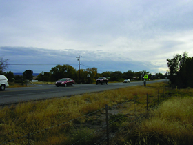
Looking south along NM 30 toward a signed
and marked school zone crosswalk near the Pueblo's
main residential area.
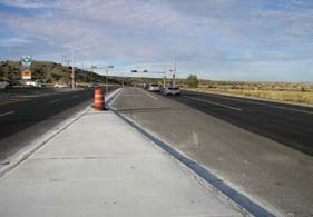
Looking north along NM 30 toward a recently
improved intersection adjacent to a convenience
store/gas station. The full traffic signal was in
place, but not operational, at the time of the audit.
FIGURE A.2 VIEWS OF RSA SITE (THE SANTA CLARA PUEBLO)
KEY RSA FINDINGS AND SUGGESTIONS:
The key findings and suggestions of the RSA are summarized in Table A.2. Where appropriate, the suggestions were divided into:
- Short-term (could be implemented prior to the anticipated opening of scenic and historic areas the following spring).
- Medium-term (could be implemented in the interim period before substantial upgrades to the corridor were started).
- Long-term (could be implemented as part of the corridor upgrades that were scheduled to start in two years).
| SAFETY ISSUE (Number and Description) | RISK RATING | SUGGESTIONS | |
|---|---|---|---|
| 1 |
Pedestrian facilities:
|
D |
|
| 2 |
Narrow Shoulder and Auxiliary Lanes:
|
C |
|
| 3 | Signal operation at Puye Cliffs access road: Drivers turning from the Puye Cliffs access road may require a full signal to safely turn left onto NM30. | C |
|
| 4 | Signing and Pavement Markings: An absence of warning signs and pavement markings may increase the collision risk at merge areas. | B |
|
| 5 | Lighting: The absence of overhead lighting limits the visibility and conspicuousness of unsignalized intersections and the school crosswalk. | B |
|
| 6 | Roadside Hazard: Two signal poles are located within the clear zone at a signalized intersection. | C |
|
| 7 |
Speed limits:
|
C |
|
KEY LESSONS LEARNED:
Conducting the RSA at the start of the parallel corridor upgrade study provided an opportunity for enhanced safety input to the corridor study. In addition to the issue-specific suggestions listed in Table A.2, the RSA team discussed longer-term suggestions to improve safety along NM 30. In particular, the RSA team recognized that the growth of the Pueblo's main residential area had generated a need to examine whether the current rural configuration and high speeds along NM 30 were still appropriate. Specifically, the RSA team suggested that NM DOT and the Pueblo consider converting the high-speed, two-lane rural highway cross-section into a four-lane urban cross-section through all or part of the Pueblo. The urban cross-section could enhance vehicle and pedestrian safety by reducing through speeds, providing facilities to better accommodate drivers turning into and out of the Pueblo's residential areas, and providing safer opportunities for pedestrians crossing the highway. In addition, since NM DOT and Pueblo staff often cited excessive speed as an issue along NM 30 (and a review of the highway collision history supported this view), the RSA Team suggested that a formal speed study could be considered as a supplement to the NM 30 corridor upgrade study.
See also the discussion of "Key Factors for Success" and "Lessons Learned" in the main text.
RSA NUMBER 3
THE JEMEZ PUEBLO: RSA OF STATE HIGHWAY NM 4 THROUGH THE PUEBLO
| Road: existing two-lane rural tribal road | |
|---|---|
| RSA Sites: |
|
| Project Environment: |  urban/urbanized urban/urbanized  suburban suburban  rural rural |
| Project Owner: | Pueblo of Jemez and the New Mexico DOT |
| Road Safety Audit | |
|---|---|
| Date of RSA: | 26-27 October 2006 |
| RSA Stage(s): |  planning/design stage planning/design stage  RSA of existing roads RSA of existing roads |
| RSA team: | staff from Pueblo of Jemez, BIA Southwest Regional Office, New Mexico DOT (District 6), Federal Highway Administration, VHB, and Opus Hamilton Consultants |
BACKGROUND:
The Jemez Pueblo, the only remaining village of the Towa-speaking Pueblos in New Mexico, is home to approximately 2,000 residents. State Highway 4 (NM 4), a minor arterial, runs through the main village area. In 2003, the highway had an estimated workweek AADT of 3,000 vehicles (rising to 5,700 over the Memorial Day weekend), reflecting use by:
- Residents of the Pueblo for travel within the Pueblo, as well as travel to neighboring communities such as Jemez Springs and Bernalillo.
- Visitors to the Pueblo and surrounding areas, including the tribe's Walatowa Visitors Center and the Red Rocks Recreation Area.
- Through traffic on NM 4, which is part of the Jemez Mountain Trail National Scenic Byway (established 1998) and provides access to the Valles Caldera National Preserve (established 2000).
Two views of NM 4 are shown in Figure A.3.
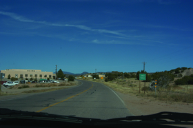
Looking north along NM 4 at the entrance to
the Pueblo of Jemez. NM 4 is predominantly
a two-lane rural road with wide shoulders,
with a speed limit of 30 mph along this segment.
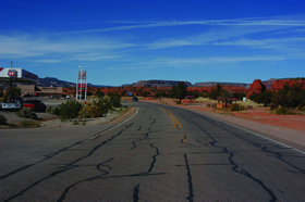
Looking north along NM 4 at the red
rocks recreational area. Roadside land
uses include the commercial area (service
station and Walatowa Visitors Center) visible
at left, and the recreational area (where
small-scale vending takes place during the
summer) at right. The speed limit along this
segment of the highway is 50 mph.
FIGURE A.3 VIEWS OF RSA SITE (THE JEMEZ PUEBLO)
KEY RSA FINDINGS AND SUGGESTIONS:
The key findings and suggestions of the RSA are summarized in Table A.3.
| SAFETY ISSUE (Number and Description) | RISK RATING | SUGGESTIONS | |
|---|---|---|---|
| 1 | Frequent Uncontrolled Accesses: Uncontrolled access to properties adjacent to NM 4 increases the risk of conflicts and collisions. | D |
|
| 2 | Pedestrian Safety: Pedestrians walking along NM 4 have no dedicated pedestrian facilities. | D |
|
| 3 | Signing, Pavement Markings, and Delineation: Missing signs, pavement markings, or delineation may limit driver guidance and increase the risk of collision. Excessive signing may distract drivers. | C |
|
| 4 | Speed: Speeds above the posted speed limit increase the risk and potential severity of crashes on NM 4. | E |
|
| 5 | Deterioration of Shoulder: Shoulder conditions may deteriorate as a result of surface drainage flows and traffic. | C |
|
| 6 | Roadside Hazards: Unshielded roadside hazards are present off the highway. | C |
|
| 7 | Intersection with Bear Canyon Road: Limited sight distances, especially at night, increase the risk of collision at this intersection. | C |
|
| 8 | School Bus Operations: School buses do not consistently operate their flashing lights when picking up and dropping off students. | D |
|
| 9 | Animals on the Highway: Animals on the highway pose a crash risk. | C |
|
KEY LESSONS LEARNED:
Cultural traditions can conflict with road safety initiatives. The RSA Team noted in its report that the Pueblo of Jemez has been supportive of efforts (like the Scenic Byways designation of NM 4) to increase tourism, preserve the environment, and improve economic development in the region. At the same time, to protect and preserve its spiritual and cultural practices, the tribe has also insisted that all recommendations for roadway improvements should consider impacts on the culture and traditional lifestyle of its members. Two examples illustrate this lesson:
- Improved night-time lighting was identified in the RSA report as one of several measures that could address pedestrian safety. Pueblo representatives were supportive of the idea, but noted that, since night-time lighting conflicts with traditional/cultural activities near the center of the community, controls that allow for manually turning street lights on or off as needed were preferred.
- Over half of all reported collisions along NM 4 in the Jemez Pueblo involved animals (primarily cattle) on the highway. Although the RSA team noted that the most effective and practical long-term measure to address livestock collisions was to install and maintain fencing to keep livestock off the road, there was extended discussion regarding whether some or all of the Pueblo lands are "open range", which would imply that it is the responsibility of road users to drive with caution and avoid livestock on the road. The RSA team suggested that efforts should be undertaken to clarify and resolve potentially conflicting laws and customs regarding the movement of livestock over public roads, with the goal of protecting road users (including both local traffic and through traffic) and livestock.
See also the discussion of "Key Factors for Success" and "Lessons Learned" in the main text.
RSA NUMBER 4
NAVAJO NATION: RSA OF HIGHWAY N-12
| Road: existing two-lane rural tribal road | |
|---|---|
| RSA Sites: |
|
| Project environment: |  urban/urbanized urban/urbanized  suburban suburban  rural rural |
| Project Owner: | Navajo Nation and the Bureau of Indian Affairs |
| Road Safety Audit | |
|---|---|
| Date of RSA: | 1-3 November 2006 |
| RSA Stage(s): |  planning/design stage planning/design stage  RSA of existing roads RSA of existing roads |
| RSA Team: | staff from Navajo DOT, BIA, Arizona DOT, Federal Highway Administration, Navajo Police, and Opus Hamilton |
BACKGROUND:
Highway N-12 is a rural minor arterial providing access to the Navajo capital at Window Rock, AZ. The highway, which is under the jurisdiction of the BIA, intersects I-40 near Lupton, AZ, and continues northward to US 191, passing through three states (Arizona, New Mexico, and Utah). This RSA has focused on the portion of N-12 north of Highway 264 between Window Rock and Fort Defiance, and also included two smaller sites south of Highway 264.
On the segment between Window Rock and Fort Defiance, Highway N-12 has an AADT ranging between 14,000 and 24,000 vehicles, reflecting use by:
- Residents of the Navajo Nation reservation, especially employees and visitors associated with the tribal government, which is centered in Window Rock.
- Residents and visitors to commercial establishments in Window Rock.
- Visitor and long-distance traffic on N-12.
The highway accommodates a substantial truck volume. Speed limits along the audit segments vary from 35 to 55 mph. Two views of N-12 are shown in Figure A.4.
Seven years (1999 through 2005) of collision summaries along N-12 were reviewed as part of this RSA. Over seven years, a total of 386 collisions were reported along N-12. Annual collision frequency peaked in 2002 with 60 reported collisions, and declined each subsequent year to a low of 21 reported collisions in 2005. Figure A.5 shows the spatial distribution of collisions along the entire highway segment from MP 0.0 to MP 58.5. Peaks are evident around MP 23/24 and MP 28/29, which correspond to the Window Rock and Fort Defiance areas.
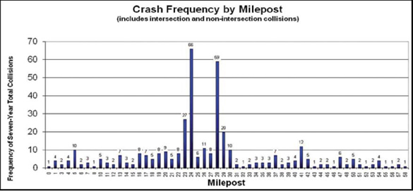
NOTE:Shows collision locations reported on N-12 over seven years (1999 through 2005). distribution is shown in one-mile segments, so (for example) all collisions at MP 24.0 through 24.9 are shown at "MP24" in the chart.
FIGURE A.4 COLLISIONS ALONG HIGHWAY N-12
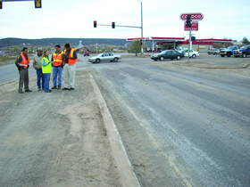
Looking north along N-12 at the intersection
with N-110 (near Fort Defiance). A 62-foot urban
cross-section is provided, consisting of two through
lanes in each direction, with curb and gutter and
turn lanes (or a raised median) at intersections.
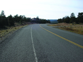
Looking south along N-12 at audit site south of
Highway 264. The cross-section is a two-lane
rural road with wide paved shoulders.
FIGURE A.5 VIEWS OF RSA SITE (NAVAJO NATION)
KEY RSA FINDINGS AND SUGGESTIONS:
The key findings and suggestions of the RSA are summarized in Table A.4.
| SAFETY ISSUE (Number and Description) | RISK RATING | SUGGESTIONS | |
|---|---|---|---|
| 1 | Signing and Pavement Marking: Worn or missing signs and pavement markings may limit driver guidance, especially at night. | D |
|
| 2 | Pedestrian Facilities: The design and maintenance of some pedestrian facilities may limit their usefulness. Pedestrians who are unable or unwilling to use pedestrian facilities may use the roadway instead, where they are exposed to vehicle traffic. | D |
|
| 3 | Poor Pavement Conditions: Cracked, worn, rutted, and dusty/muddy pavement may reduce driver control (especially for motorcyclists), particularly on N-12 between N-110 and Hwy 264. | C | pavement repair and rehabilitation |
| 4 |
Intersection of N-12 and N-100 (Window rock):
|
C |
|
| 5 |
Intersection of N-12 and N-110 (Fort Defiance):
|
C |
|
| 6 |
N-12 near St Michael's School (between MP22 and MP23):
|
C |
|
| 7 |
S-curve on N-12 between MP13 and MP14:
|
C |
|
KEY LESSONS LEARNED:
See the discussion of "Key Factors for Success" and "Lessons Learned" in the main text.
