USA Banner

Official US Government Icon

Official websites use .gov
A .gov website belongs to an official government organization in the United States.

Secure Site Icon

Secure .gov websites use HTTPS
A lock ( ) or https:// means you’ve safely connected to the .gov website. Share sensitive information only on official, secure websites.

U.S. Department of Transportation U.S. Department of Transportation Icon United States Department of Transportation United States Department of Transportation

Noteworthy Practices

Left Nav - HSA Learn Safety

Inexpensive Nighttime Inspection Kits to Improve Rural Sign Safety

Original publication: 2013 National Roadway Safety Awards Noteworthy Practices Guide; FHWA-SA-14-002; 2013
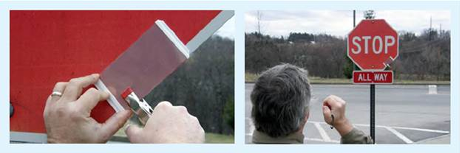

"Two photographs: 1) Two hands attaching an inspection panel to a sign, and 2) A man, approximately ten yards away, looking at the sign/inspection panel"

Attaching inspection panel to target sign.

Viewing sign with inspection panel attached
(done at night during actual use).


Describe the roadway safety situation or state before the new practice was implemented. What was the safety issue, problem, or gap?

Three County Highway Departments in western New York did not have access to the necessary equipment for inspecting local signage for compliance with the new Manual on Uniform Traffic Control Devices (MUTCD) sign retroreflectivity standards. In short, there was not enough equipment to inspect the retroreflectivity of all signing in the region.

What were the key challenges that needed to be addressed before the new practice could be implemented?

Required equipment, such as a retroreflectometer, carries a heavy price tag. Without accurate testing equipment, these local counties had to “guess;” erring on the side of caution, the replaced signs that actually might have complied with MUTCD standards (had they been properly inspected).

Describe the new practice:

In the summer of 2011, the Cornell University Local Roads Program (CLRP) initiated a project with the three County Highway Departments and created a sharing agreement so that each agency had access, at a low cost, to a retroreflectometer for inspecting local signing in support of the new Manual on Uniform Traffic Control Devices (MUTCD) sign retroreflectivity standards. This sharing program included all three counties as well as local jurisdictions in the respective counties (i.e., towns, villages, and one city).

In addition to the retroreflectometer sharing agreement, CLRP developed a total of 50 inexpensive sign inspection kits, costing less than $50 each. The kits use clear “overhead projector” sheets in layers to degrade the retroreflectivity of small comparison panels of different colors to a conservative level above the minimum retroreflective levels identified in Table 2A-3 of the MUTCD. The clear overhead sheets are the same ones used with overhead projectors and are available at office supply stores.

List the key accomplishments that resulted from the new practice. Include the roadway safety improvements.

  • Improved availability of accurate retroreflectivity testing tools to three local counties, improving sign retroreflectivity quality (and improving compliance with new MUTCD standards) along rural routes.

What technical and/or institutional changes resulted from the new practice?

  • Sharing agreement for the retroreflectometer
  • Development of a cost effective inspection kit

What benefits were realized as a result of the practice?

The biggest benefit realized were the savings in the form of time and money. In general, the sharing agreement led to a reductions in overtime costs for nighttime inspections, reductions in the number of signs that need to be replaced annually, and an easily compiled, inexpensive ($50) portable field kit that is available at all times.

More specific benefits were:

  • More accurate nighttime sign inspections, virtually eliminating “guessing” about the quality of a particular sign (reducing the number of signs that were replaced unnecessarily).
    • Example: Wyoming County, New York
      • Prior to receiving the kits, sign technicians would err on the side of caution and replace many signs that were actually adequate.
      • With the kits, they replaced 20 percent fewer signs than they had replaced previously due to concerns about retroreflectivity.
  • Besides being more accurate, retroreflectivity inspections were faster.
    • Example: Wyoming County, New York
      • Saved a day of overtime, inspecting all the county's signs in only 3 nights.
  • From the Wyoming County, New York example: Savings from the reduction of 2 full shifts of overtime work and approximately 30 signs amounts to $3,000 each year.

Is the practice you are submitting from a larger report, journal, or other document? Yes

2013 National Roadway Safety Awards Noteworthy Practices Guide
Publication FHWA-SA-14-002

Contact

David P. Orr, Ph.D.
Cornell Local Roads Program
607-255-8033
David.Orr@cornell.edu
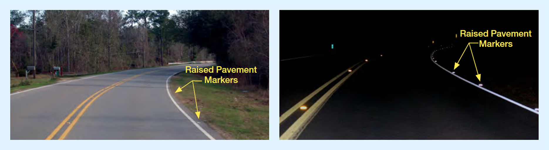
Raised Pavement Markers (RPMs) – A Low-Cost Alternative for Run-off-the-Road Crashes

Original publication: 2013 National Roadway Safety Awards Noteworthy Practices Guide; FHWA-SA-14-002; 2013


"Two photographs of a curve with 20 feet RPM spacing, one during the day and one at night. The photograph at night shows the markers reflecting light."

Example of 20 feet RPM spacing for a curve.

Example of same location at night.

Describe the roadway safety situation or state before the new practice was implemented. What was the safety issue, problem, or gap?

With help from the Federal Highway Administration (FHWA) and Alabama Department of Transportation (ALDOT), Mobile County, Alabama determined that 10 rural roadways within the county rated the highest in the State for run-off-the-road crashes. These roadways, totaling more than 68 miles, had experienced 224 run-off-the-road type crashes between 2005-2008, resulting in 7 fatalities and 152 injuries.

What were the key challenges that needed to be addressed before the new practice could be implemented?

The challenge was to determine the most effective low-cost treatment. While rumble strips can reduce run-off-the-road crashes, installing them requires large machinery, manpower with technical skills, and oftentimes additional right of way, making them a cost-prohibitive solution.

Describe the new practice:

To counter these cost concerns, Mobile County and ALDOT implemented a program for the systematic application of raised pavement markers (RPM) to improve sight distance recognition and guidance along the edge of the pavement, especially during wet weather conditions at night. One-directional, white RPMs adjacent to the white edge-line stripe were easily installed using existing traffic maintenance department equipment and manpower.

What technical and/or institutional changes resulted from the new practice?

The program set guidelines for consistent implementation for all roadways within the county. RPMs were placed just outside the existing edge-line stripe.

  • Tangent sections of roadways would have RPMs installed at 80 feet spacing.
  • At the approach to a curve having an advance warning curve sign, the spacing would be 40 feet apart from sign location to the beginning of the curve.
  • In the curve, the spacing would be 20 feet until reaching the tangent section.

What benefits were realized as a result of the practice?

Based on 2009-2012 crash data, crashes on the initial 10 roadways treated dropped from 224 to 33, from 7 fatalities to 0, and from 152 injuries to 10. The average number of crashes for all 10 roadways decreased by 85.3 percent. RPMs give critical guidance to drivers, especially along dark and rainy county roadways. As a result of this pilot project, they are now included in most roadway projects in Alabama.

Is the practice you are submitting from a larger report, journal, or other document? Yes

2013 National Roadway Safety Awards Noteworthy Practices Guide
Publication FHWA-SA-14-002

Contact

James Foster
Mobile County Engineer Office
251-574-8595
JFoster@mobilecounty.net

FHWA Arizona Division Office Uses Technology Transfer (T2) Funds to Create Local Agency Grant Program


Roadway Safety Issue, Problem, or Gap:

Roadway departures account for approximately half of all fatal crashes nationwide. Pavement edge drop-off has been linked to many serious and fatal roadway departure crashes; drivers who leave the roadway may overcompensate by steering too hard, causing a vehicle to fishtail, swerve into another lane, or completely leave the roadway. The Federal Highway Administration (FHWA) advocates installing Safety Edge™ to mitigate vertical drop-offs. In Arizona, most local agencies did not have the expertise or equipment to include Safety Edge™ on their roadway projects. To address this gap, the Arizona Department of Transportation (ADOT) Local Transportation Assistance Program (LTAP) worked with the FHWA Arizona Division Office to create a program to provide the Safety Edge™ equipment and training to local agencies.

Description of Practice

I think part of it (Local Agency Safety Edge™ Grant Program) was time-consuming because we were learning the best ways to structure the program as we go, but in the end I felt it was definitely worth it, because the program was so successful! Our program had 15 devices, all of which but two have been given to agencies, and more Tribes are interested.

Kelly LaRosa, FHWA Arizona Division

The FHWA Arizona Division Office used Technology Transfer (T2) funds from the Division of Field Service Regional Offices to purchase fifteen Safety Edge™ Shoe Devices exclusively for local agencies, allowing Safety Edge™ to be more broadly implemented throughout the state. Agencies submit an application to receive a Safety Edge™ Shoe Device and training.

The Division Office and the ADOT-LTAP actively promoted Safety Edge™ at industry meetings/conferences and at MPO and Council of Government meetings. ADOT LTAP also built up its internal capacity by participating in Safety Edge™ Train-the-Trainer events.

Key Accomplishments and Results:

  • Increased knowledge and awareness about Safety Edge™ at local agencies, including among Tribes.
  • Increased use of Safety Edge™ in new paving projects. Contractors are marketing Safety Edge™ to their clients, offering it with paving projects, and support the safety benefits.
  • Encouraged innovation applying the technology. Some local agencies have incorporated Safety Edge™ with a thickened edge design detail. One agency, Santa Cruz County, is pursuing a shoulder widening project and adding Safety Edge™ by milling the existing roadway a few feet.
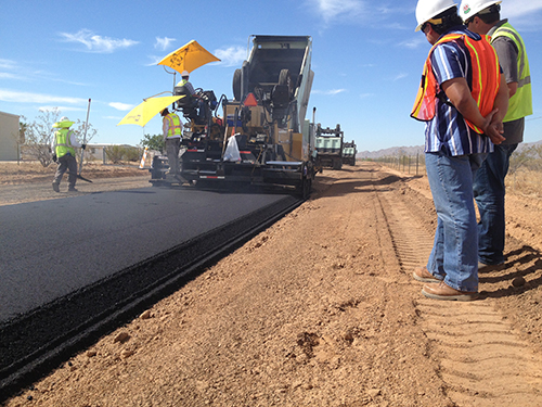
"Photograph of a paving crew laying down a coat of asphalt"
Figure 1: Maricopa County, AZ Note


Contact

Brian Hurst
Tennessee Department of Transportation
615-741-2208
Brian.Hurst@tn.gov

Tennessee DOT Establishes Project Safety Office to Expedite the Completion of Intersection Projects

Original publication: N/A


Roadway Safety Issue, Problem, or Gap:

Between 2002 and 2005, Tennessee experienced 777 total fatalities at intersections across the state. In 2005, Tennessee was identified as a Focus State in Intersections by the Federal Highway Administration (FHWA) Office of Safety. A focus state in intersection is defined as one of several states that contribute to having the highest number of intersection fatalities nationwide.

Description of Practice

Following a 2007 Intersection Safety Plan Workshop, the FHWA Tennessee Division and the Tennessee Department of Transportation (TDOT) collaborated to develop an Intersection Action Plan. In 2010, TDOT began implementing the plan with the following process improvements:

  • Institute no-plans contracts to expedite the award of contracts based on pre-established safety requirements.
  • Develop an agreement with TDOT Environmental Division to allow TDOT to submit intersection locations prior to site visits to gain NEPA approval in eight weeks.
  • Develop an Intersection Implementation Guide to standardize the steps for completing intersection projects.

Challenges in Implementing the New Practice

After the plan was developed in 2007, TDOT encountered challenges in the implementation of the Intersection Safety Action Plan, including:

  • Lack of trust in systemic application: TDOT did not want to deploy the action plan without going to every site and reviewing all crash data to identify issues.
  • No true ownership: No TDOT office had the time to implement the plan.

How Challenges Were Overcome

  • In November 2009, the FHWA Office of Safety Intersection Team contacted TDOT and the TN Division to develop a strategy to implement the Intersection Safety Action Plan.
  • The TDOT Project Safety Office was created in 2010. This office implemented the Intersection Safety Action Plan.

Benefits Realized From the Practice

Tennessee has reduced intersection safety fatalities by at least 26% across the state. Tennessee is no longer a FHWA Focus State for Intersections. Furthermore, Tennessee has become more innovative with intersection designs by implementing alternative intersection designs including roundabouts, J-Turns, and Diverging Diamond Interchanges.

Contact

Brian Hurst
Tennessee Department of Transportation
615-741-2208
Brian.Hurst@tn.gov

South Carolina Addresses Intersection Safety through Low-Cost, Systematic Improvements

Original publication: N/A


Key Accomplishments

The South Carolina Department of Transportation (SCDOT) began identifying safety improvements to be deployed systematically at intersections across the State in 2008 as part of the Federal Highway Administration's (FHWA) Office of Safety Intersection Focus State initiative. SCDOT believed these improvements would reduce the number of intersection-related fatalities and serious injuries, which was one of the goals defined in SCDOT's 2007 Strategic Highway Safety Plan (SHSP). As part of this process, SCDOT used a 5-year analysis of statewide crash data to identify high-crash intersections and recommend improvements—primarily signing, pavement markings, and signal enhancements. Based on these findings, a list of 2,204 intersections was compiled in the South Carolina Intersection Safety Implementation Plan (ISIP), and SCDOT sought a contracting mechanism to implement the recommended improvements identified in the ISIP within a three-year time frame.

Following the identification of intersections where countermeasures would be applied, SCDOT developed a unique contract vehicle structured to accommodate the systematic approach proposed in the ISIP. The contract was a single, statewide, three-year contract, renewable each year, which allowed for adjustments to be made to improve the quality of the work in subsequent years. The contract was structured to treat approximately one-third of the intersections identified in the plan each year for 3 years.

Throughout the project, the selected contractor and the subcontractor developed a Field Installation Work Book that contained all pertinent information on installation at a particular site, including final approved drawings, installation checklists, and punch list forms. In addition, the contractor and subcontractor developed a reconciliation spreadsheet to manage multiple crews and to document and verify installed quantities for payment during the course of the fast-paced project. The contractor and subcontractor also used a project management website to provide changes to intersection plans to SCDOT on a regular basis and report on the progress of work performed. The contract defined the minimum requirements of the website; however, the website developed ultimately included additional functionality.

Because 23 USC 120(c) allows certain safety improvements such as signing and pavement markings to be eligible for Federal funding, the project was entirely federally funded. The consistency between South Carolina's ISIP and SHSP and the identification of the projects through a systematic, data-driven process allowed for the projects to be implemented using Highway Safety Improvement Program (HSIP) funds.

Through this project, SCDOT made improvements to more than 2,200 intersections that account for forty four percent of all intersection crashes in South Carolina. In deploying this project, SCDOT employed a statewide, low-bid contract vehicle that allowed for uniform implementation resulted in administrative efficiencies and economies of scale through decreased per-unit prices on bulk purchases.

Results

The project has been successful in terms of its outputs and short timeframe, addressing over 2,200 high-crash-frequency intersections in three years. FHWA plans to evaluate the safety effects of SCDOT's low-cost systematic intersection improvements as part of its Evaluation of Low cost Safety Improvements Pooled Fund Study.

Contact

Joey Riddle
South Carolina DOT
Safety Program Engineer
(803) 737-3582
RiddleJD@dot.state.sc.us

Daniel Hinton
FHWA South Carolina Division
Safety and Operations Engineer
(803) 253-3887
Daniel.Hinton@dot.gov

Florida Uses Predictive Methods found in the Highway Safety Manual (HSM) for Alternative Selection in Florida (HSM Case Study 3)

Original publication: Highway Safety Manual Case Study 3: Using Predictive Methods for Alternative Selection in Florida


Background

The American Association of State Highway and Transportation Officials' (AASHTO's) Highway Safety Manual Part C Predictive Method (Chapters 10-12) estimates crash frequency and severity. The predictive method uses equations known as Safety Performance Functions (SPFs) to estimate the predicted average crash frequency as a function of traffic volume and roadway characteristics (e.g., number of lanes, median width, intersection control, etc.). The HSM provides SPFs for rural two-lane, two-way roads; rural multilane highways; and urban and suburban arterials. The predictive method enables informed decision making throughout the project development process, including the selection of alternative roadway designs.

Key Accomplishments

Florida DOT (FDOT) District 7 (Tampa area) volunteered to analyze corridor widening project alternatives on State Road (SR) 574 using the HSM predictive method. FDOT used the predictive method for urban and suburban arterials (Chapter 12) to evaluate the predicted safety performance of each alternative over a 20-year horizon. They used the urban arterial SPFs (refer to HSM equation and tables) and adjusted for the proposed geometric conditions based on the crash modification factors (CMFs) for median width provided in the HSM (Table 12-22).

Results

Based on these results, a four-lane divided alternative was predicted to have a crash cost savings of approximately $4.2 million compared to a five-lane with two-way left-turn lane alternative. A benefit-cost ratio was calculated by dividing the crash cost savings by the difference in right-of-way (ROW) costs.1 The resulting benefit-cost ratio was equal to 2.64, illustrating that the benefit obtained through improvement in crash costs more than offset the differential in ROW costs. The results of this analysis were used to justify the additional ROW costs of the four-lane divided section.

The HSM predictive method enables the design engineer to estimate quantitative safety impacts of various design alternatives and provide justification for their design decisions. For the SR 574 study in particular, the loss of parking at the post office necessary to construct the four-lane divided section, may have been difficult to justify to the post office and the public based on engineering judgment alone. However, the use of the predictive method provided the design engineer with quantifiable evidence on why the four-lane alternative is preferred based on the crash cost savings.


1 Although there are differences in costs associated with construction, ROW was found to have the most significant impact, and therefore, ROW was the only cost considered in the economic analysis.

"Highway Safety Manual logo"

Contact

David O'Hagan
Florida Department of Transportation
(850) 414-4283
David.OHagan@dot.state.fl.us


Florida Highway Patrol Piloting Signal Four Analytics, a Web-based Crash Mapping and Analysis Tool

Original publication: Signal Four Analytics, a Web-based Crash Mapping and Analysis Tool – Florida Highway Patrol(Website)


Key Accomplishments

Traffic crash data is available now in greater detail than ever, but making sense of this data remains a challenge to law enforcement, transportation planners, and traffic engineers. These professionals need powerful, accessible, and affordable tools to explore the spatial and logical relationships that drive decisions on resource allocation and project prioritization. Signal Four Analytics aims to address these needs by providing current crash and streets data paired with interactive analysis and visualization tools, accessible via any modern web browser.

Results

Florida Highway Patrol (FHP) is currently the statewide pilot agency for this system. The GeoPlan Center and FHP are working together to ensure that the system will fulfill the crash analysis needs of law enforcement for identifying critical safety areas in order to apply enforcement education countermeasures effectively to reduce fatalities and injuries on Florida's roadways.

Crash data—long and short form, collected electronically by FHP officers at crash sites throughout the state—is transmitted nightly to the GeoPlan Center and loaded into the Signal Four Analytics database. Live database statistics are shown above and to the right.

Once the pilot phase is complete, Signal Four Analytics will be extended for use to interested traffic engineering, transportation planning, and other law enforcement agencies in Florida.

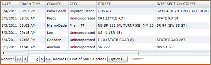
"Screenshot of the Signal Four Analytics Tool"

Figure 1. Signal Four Analytics Web Interface

"Two enlarged screenshots from the Signal Four Analytics Tool, the first showing data on a map as individual points, and the second showing the same data as clusters"

Figure 2. Crash data can be viewed spatially in the context of a map. The system can present the data as individual points, or collectively as clusters. The map views allow analysts to quickly gain an intuitive understanding of the spatial distribution of crashes.

Figure 3. Crash attributes and derived statistics can be viewed in tabular format. Tables interact with the map view—as records are selected, associated points are highlighted on the map (and vice-versa).

"Screenshot from the Signal Analytics Tool, showing a horizontal bar chart of the distribution of crashes by day of the week"

Figure 4. The distribution of crashes can be charted according to any number of attributes (day of week, for example).

Contact

Major Richard S. Mechlin
Office of Strategic Services, Florida Highway Patrol
2900 Apalachee Parkway, MS-43
Tallahassee, FL 32399
850-617-2377
richardmechlin@flhsmv.gov

Dr. Ilir Bejleri
954-214-7885
Ilir@ufl.edu

Knox and Oldham Counties in Kentucky Use High Friction Surface Treatments to Reduce Occurrence of Road Departure Crashes – Kentucky

Original publication: Every Day Counts Project Case Study: High Friction Surface Treatments – Kentucky Transportation Cabinet (KTC)(PDF, 816kB)


Key Accomplishments

Roadway departure crashes composed nearly 70 percent of the crashes on Kentucky highways. Because these crashes tend to lead to injury or death, the Kentucky Transportation Cabinet (KTC) decided to treat these problem curves as top priority. For any half-mile roadway section having eight or more wet weather crashes over a 5-year period, the KTC proactively applied High Friction Surface Treatment (HFST) using calcined bauxite for the aggregate if the pavement was in good condition.

Results

Oldham County applied HFST in 2009 to treat one horizontal curve. Prior to the HFST, there were 53 wet weather crashes and three dry weather crashes observed over a 3-year period (18.67 average crashes/year). After the treatment, five wet weather crashes and no dry weather crashes were observed over a period of 3.18 years (1.57 crashes per/year).

Knox County installed HFST at one intersection in 2011. The HSFT was installed to address rear-end crashes at the intersection. The friction treatment was only applied on US 25 in the southbound lane, which has a downgrade approach. For a 3-year period prior to the installation, there were six wet weather crashes and 27 dry weather crashes (11 crashes/year). The crashes were mostly rear-end crashes. During the 1.3 years after the installation, there were two wet weather crashes and five dry weather crashes (5.38 crashes/year).

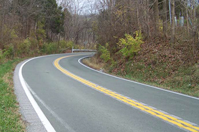
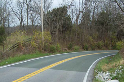
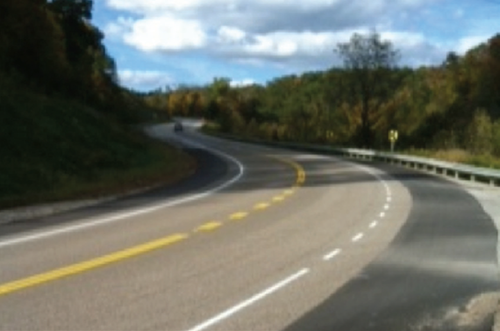
"Photograph of a horizontal curve on KY 22 with HFST installed""Photograph of a horizontal curve on KY 22 with HFST installed"

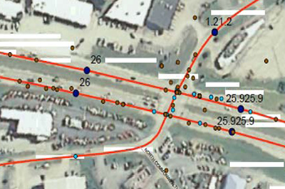
Figures 1 and 2. Oldham County, KY; KY 22, MP4.36 4.44; HFST Installed In August 2009 to Treat One Horizontal Curve

"Photograph of US 25 Southbound Lane, showing an area being installed with HFST""Aerial photograph of US 25 at its Intersection with KY 1629"

Figures 3 and 4. Knox County, KY; US 25 Southbound Lane, at its Intersection with KY 1629 - HFST Installed In April 2011

Contact

Tracy Lovell
P.E., Transportation Engineer
Kentucky Transportation Cabinet
Tracy.Lovell@ky.gov

Joseph Cheung
P.E., HFST Lead
FHWA Office of Safety
Joseph.Cheung@dot.gov

Wirt and Mercer Counties in West Virginia Use High Friction Surface Treatments to Reduce the Occurrence of Road Departure Crashes – West Virginia

Original publication: Every Day Counts Project Case Study: High Friction Surface Treatments – West Virginia Department of Transportation(PDF, 814kB)


Key Accomplishments

West Virginia has a high number of run-off-the-road crashes. Their goal of applying High Friction Surface Treatment (HFST) at these locations is to reduce the number of crashes. They intend to look at the total number of accidents 3 years after application.

Results

WV DOT officials will look at the total number of accidents 3 years after the application of these HFST treatments.

WV 14 in Wirt County is a typical two-lane road in West Virginia with an ADT of 3400. The site is located at a six-degree horizontal curve. Prior to application, this site had four wet weather crashes in a span of 3 years. No skid testing reading was available prior to the project, but it had a reading higher than 69 after installation. The project was completed in October 2012. The total linear feet of installation is 420.

WV 20 in Mercer County is a two-lane road in southern West Virginia with an ADT of 7200 compromising mostly of commuters. The site is located at a series of horizontal curves. Prior to the application, this site had four run-off-the road crashes in a span of 3 years. No skid testing reading was available prior to the project, but it had a reading higher than 69 upon project completion. The project was completed in August 2011. The total linear feet of installation is 2,200.

"Photograph of an HFST-treated horizontal curve of WV 14 in Wirt County"
Figure 1. Wirt County - WV 14 at MP 15.48


"Photograph of an HFST-treated section of WV 20 in Mercer County"
Figure 2. Mercer County - WV 20 at MP 16.42 between Princeton and Athens, WV


Contact

Donna Hardy
P.E., Mobility and Safety Engineer
WV Division of Highways, Traffic Engineering Division WV DOT
Donna.J.Hardy@wv.gov

Joseph Cheung
P.E., HFST Lead
FHWA Office of Safety
Joseph.Cheung@dot.gov

California Department of Transportation Installs High Friction Surface Treatment on Los Angeles On-Ramp to Reduce Wet Pavement Collisions – California

Original publication: Every Day Counts Project Case Study: High Friction Surface Treatments – California Department of Transportation(PDF, 615kB)


Key Accomplishments

Caltrans Roadway Departure Safety Plan in 2011 identified 179 locations and approximately 50 other locations where High Friction Surface Treatment (HFST) has been or will be placed.

California has placed 10 HFST applications to date. However, 50 additional applications are planned, including one at a high-speed, signalized intersection. The majority of the applications will be for the end of on-ramps and on the curves of two-lane roadways.

"Photograph of the Sepulveda onramp"
Figure 1. Rte. 105 Sepulveda Boulevard onramp in Los Angeles, CA. HFST installed in February 2011


Caltrans is moving forward with the projects as a result of information obtained from other states and information provided during webinars. Based on the information from webinars, Caltrans' specifications call for calcined bauxite only. Previously, Caltrans mainly used open-grade asphalt concrete (OGAC) to reduce wet pavement collisions along with grinding and grooving. However, OGAC could not be installed at locations where there were freezing temperatures. An additional benefit of HFST when compared with OGAC is the ability to install on any pavement surface without concern for cross drainage.

Results

The I-105 Sepulveda Blvd. on-ramp, a primary egress point from the Los Angeles Airport, was notoriously closed during rain events to prevent expected crashes. The average daily traffic is 31,000. Crashes occurred as a result of the tight curvature, the low friction, and aggressive driving by motorists. The closure of this highly utilized ramp resulted in numerous complaints to Caltrans. The latest five years of crash data showed that 68 of the 85 crashes were wet pavement crashes. Since Caltrans applied HFST to about 1,300 linear feet of the ramp, it has not been closed. The pre- and post-application friction values were 32 and approximately 60, respectively. Due to the volumes of crash data processed, post-application crash experience data is not available at this time.

Contact

Robert Peterson
Branch Chief, Caltrans
Highway Safety Improvement Program
Robert.Peterson@dot.ca.gov

Joseph Cheung
P.E., HFST Lead
FHWA Office of Safety
Joseph.Cheung@dot.gov