USA Banner

Official US Government Icon

Official websites use .gov
A .gov website belongs to an official government organization in the United States.

Secure Site Icon

Secure .gov websites use HTTPS
A lock ( ) or https:// means you’ve safely connected to the .gov website. Share sensitive information only on official, secure websites.

U.S. Department of Transportation U.S. Department of Transportation Icon United States Department of Transportation United States Department of Transportation

Noteworthy Practices

Left Nav - HSA Learn Safety

Caltrans Uses Local Road Safety Manual to Improve its Data-driven Approach to Statewide Safety Project Selection

Summary from Assessment of Local Road Safety Funding, Training, and Technical Assistance: Benefit/Cost Tool and Local Road Safety Manual


Background

Fifty percent of California's Highway Safety Improvement Program (HSIP) funds are dedicated to local roads. The approximately $100 million-per-year program is managed by the Caltrans Division of Local Assistance (DLA), which is responsible for programming the funds to local road safety projects. As a part of the process, DLA sets criteria for HSIP project applications, reviews applications for accuracy, and selects projects. The division does not identify the projects for the local jurisdictions or administer the projects once selected, but instead provides guidance, tools, and training so the local jurisdictions are empowered to make informed decisions on effective safety improvements.

When the HSIP program first started, the application process was very basic, but has evolved into a data-driven process. To improve Caltrans's overall data-driven approach to statewide safety project selection and to maximize the long-term safety improvements across California, DLA developed Local Roadway Safety: A Manual for California’s Local Road Owners. The manual provides an easy-to-use, straightforward, comprehensive framework of the steps and analysis tools local jurisdictions would need to proactively identify locations with roadway safety issues and the appropriate countermeasures.

Benefits

Developing this resource has improved local agencies' ability to perform benefit/cost calculations for project applications. Two-and-a-half years ago, the average benefit/cost ratio on a project was approximately 8, but currently it is approximately 13.5. Local agencies are submitting applications for projects with greater lifesaving benefits. Local agencies understand the necessity of the data-driven process. The division also has seen an increase in positive communication with local agencies.
Contact

FHWA Office of Safety staff contacts by safety function

Interoffice Safety Groups at Washington State DOT Use Quantitative Data Evaluation to Determine Strategies Across the 4Es

Original publication: Safety Data Decisionmaking at WSDOT


Background

Unique among State Departments of Transportation, the Washington State Department of Transportation (WSDOT) does not have a centralized safety office. Rather, safety is central to decisionmaking across the agency; the offices of planning, traffic operations, design, risk management, and maintenance all work together to build and maintain safe roadways in the State. The agency's State-level highway safety program is coordinated by three cross-cutting groups: the Highway Safety Executive Committee, the Highway Safety Working Group, and the Highway Safety Issues Group.

The Practice

WSDOT relies upon these three cross-cutting groups to ensure that expert judgment guides the transportation planning and project selection process in Washington State. These three groups play an important role in identifying the State€™s safety needs and providing guidance to WSDOT regional offices in support of safety project selection.

Benefits

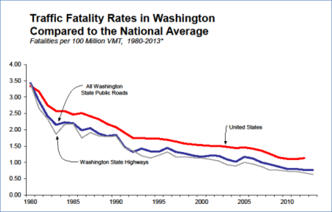
One key benefit of WSDOT's interoffice safety groups is their focused ability to address the factors contributing to crashes using a “4E” approach, which uses quantitative data evaluation of contributing factors to crashes to determine appropriate engineering, education, enforcement, and emergency medical services strategies. This interoffice approach enables the agency to target statewide safety priorities by coordinating activities between various parts of the agency, including: programming, design, traffic operations, risk management, and maintenance. Due in part to the State's safety-related innovations, Washington has observed a continued reduction in the number of fatal crashes. In fact, Washington State has averaged 22 fewer traffic fatalities and 80 fewer serious injuries each year between 2002 and 2011 (see Figure 1). WSDOT anticipates that, with continued highway safety improvements, this figure will continue to decline.

"Line graph with three plotted lines that show traffic fatalites per million Vehicle Miles Traveled on Washington State highways, on all Washington State public roads, and the U.S. average from 1980 to the present. The graph shows a downward trend for all three, as well as that the U.S. average has consistently been the highest of the three, all Washington State public roads the next lowest concistently, and then Washington State highways the lowest consistently."
Figure 1: Traffic fatality rates in Washington compared to the national average. (Courtesy of WSDOT)


Louisiana Department of Transportation and Development Provides Reduced Data-collection Costs to Local Agencies While Ensuring Data Consistency

Original publication: The Louisiana Department of Transportation and Development's Local Agency Data Collection Effort


Background

The Louisiana Department of Transportation and Development (LADOTD) recognizes the importance of data-driven operations, design, and safety decisionmaking on both State and local roadways. The State's Strategic Highway Safety Plan (SHSPs) encourages the use of safety data analysis tools that make use of quality crash, roadway, and traffic data to improve safety outcomes. In an attempt to streamline the data collection process and reduce costs, LADOTD has encouraged local agencies and metropolitan planning organizations (MPOs) to join a larger statewide data collection effort.

In 2010, LADOTD initiated a multi-year effort to collect roadway inventory data on all public roads in Louisiana. LADOTD began this effort in response to the strong need for roadway data and in anticipation of future requirements for data collection, such as those included in the Moving Ahead for Progress in the 21st Century Act (MAP-21). The agency decided to collect all of the Fundamental Data Elements (FDE) - a subset of the Model Inventory of Roadway Elements (MIRE) identified by FHWA as necessary to enhance safety analyses on all public roads in preparation of a State's SHSP.

The Practice - Integrated Data Collection Efforts

  • As part of this local data collection effort, the Department has taken steps to allow local agencies to add on additional data elements at reduced costs. While LADOTD is collecting the MIRE FDE, including the number of lanes, sidewalks, turn lanes, and type of intersections, there is a large set of additional data elements that LADOTD allows local agencies, MPOs, and parishes to collect at an additional cost.
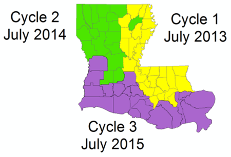
  • LADOTD contracted with Fugro Roadware in 2013 to collect data, including right-of-way videolog and asset inventory on all public roads, in three two-year cycles (see Figure 1). In addition to making the data available to local agencies at no cost, the contract allows for local agencies to collect additional data elements at a reduced fee (typically 10 percent off published rates).
alt="Louisiana county map colored to show the three two-year data collection cycles: Cycle 1, July 2013, yellow, northeast section; Cycle 2, July 2014, green, northwest section; and Cycle 3, July 2015, violet, southern section"
Figure 1: Roadway data collection cycles. (Courtesy of LADOTD)


Benefits

  • Barriers to the use of roadway safety data by Local agencies are lifted. LADOTD provides reduced data-collection costs to local agencies, while also ensuring the consistency of local roadway data collected in the State.
  • By reducing barriers to local data collection, LADOTD is supporting an enhanced understanding of local roads and their safety issues. Given that 73 percent of roadways in Louisiana are owned and maintained by local agencies, this expansion in data collection has the potential to make a large impact on roadway safety in the State.

Illinois DOT Provides Local Public Agencies with Assistance on the Use of Safety Data

Original publication: Safety Data Support to Local Public Agencies


Background

The Illinois Department of Transportation (IDOT) is committed to reducing the number of fatalities on Illinois roadways. To this end, the IDOT Bureau of Safety Engineering, which was initially created in 2004, develops, implements, and manages a multi-faceted program to reduce traffic-related deaths and injuries in the State of Illinois. As part of this mission, IDOT addresses traffic safety needs on both State-owned roads and roads owned by local public agencies (LPAs). Because local public roads constitute approximately 125,000 of the 145,000 centerline roadway miles in Illinois, improving local road safety is a major priority for IDOT.

One key component of improving safety on local roads is enhancing the safety data capabilities of LPAs and IDOT District Offices. IDOT's Bureaus of Safety Engineering and Local Roads and Streets offer safety analysis tools, provide safety data training and technical assistance, and promote local access to crash and roadway data.

Practices

  • Safety Analysis and Highway Safety Improvement Program (HSIP) Funding - IDOT uses a HSIP Benefit-Cost Tool that helps IDOT and LPAs determine whether a project is an appropriate and cost effective use of HSIP funding.
  • Training - IDOT Bureau of Safety Engineering provides training on the Highway Safety Manual (HSM) directly to the nine District Offices in the State.
  • Technical Assistance - IDOT Bureau of Safety Engineering also offers direct technical assistance to support safety programs and safety data analysis at the local level.
  • Data Sharing - IDOT communicates safety data to counties and other LPAs through the Bureau of Local Roads and Streets and is working on a new Safety Portal that will provide LPAs with improved access to crash data.

Benefits

IDOT is working to reduce the number of deaths and serious injuries due to crashes on Illinois' local roads. By promoting the use of the HSIP Benefit-Cost Tool, IDOT ensures that the HSIP project selection process makes the most economical use of limited safety funding. Through the use of improved safety data sharing abilities, Illinois has improved its project submittal process; safety projects are submitted more quickly than ever before. IDOT's technical assistance and data-sharing efforts allow the agency to support Illinois' counties as they program projects to improve the safety of local roads in the State. Overall, IDOT has seen a transition from reactive safety projects to a more proactive approach that considers common contributing factors to roadway safety.

Michigan Undertakes Initiatives to Encourage a Data-Driven Approach to Local Roadway Safety

Original publication: Initiatives to Encourage a Data-Driven Approach to Local Roadway Safety


Background

To maximize returns on investment in preparing, utilizing, and maintaining a strong safety data system, the Michigan Department of Transportation (MDOT) has undertaken a number of programs that make use of roadway, traffic, and crash data to improve safety on local- and State-owned roads in the State of Michigan.

Like many states, Michigan faces the challenge of addressing a large number of fatal crashes on non-State-owned highways, which comprise roughly 90 percent of the roadway miles and the majority of roadway fatalities in Michigan. To improve safety on local roads, Michigan has participated in several initiatives that help bolster the State's multifaceted roadway safety program by providing local agencies with meaningful, timely access to crash data, as well as tools for data analysis and training to manage their safety processes.

The Practices

  • Local Safety Initiative - A technical assistance offering, MDOT provides participating local agencies, as part of the Local Safety Initiative, with site-specific analysis, including ranking reports for intersections and segments. At no cost to local agencies, MDOT staff visit the agencies to conduct one- to two-day field reviews with staff to discuss locations of interest.
  • Roadsoft - As part of its local safety efforts, MDOT supported the expansion of a GIS-based roadway management system known as Roadsoft. Among many other features and functions, Roadsoft provides local agencies timely crash data, as well as tools to analyze crash trends and diagnose crash patterns.
  • Region-Specific Spreadsheets - As an early adopter of the Highway Safety Manual (HSM), MDOT participated in AASHTO's HSM Lead State Initiative, which encouraged highway agencies to use the HSM. As part of this initiative, MDOT developed an implementation plan for the HSM that included the regional calibration of predictive spreadsheets and Safety Performance Functions (SPFs) - equations that estimate expected average crash frequency as a function of traffic volume and roadway characteristics.
  • Crash Reporting - In addition to the Local Safety Initiative, MDOT has also taken steps to address the quality of the crash collected on local and State-owned roadways. MDOT provides input into the Michigan State Police's training programs and materials to ensure quality reporting. Through the program, MDOT is able to emphasize what elements of crash reporting are of particular importance and how exactly they should be documented in the system.

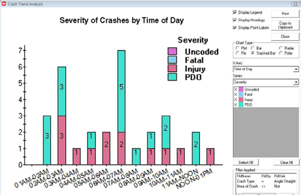
"Screenshot from Crash Trend Analysis application which is displaying a color-coded vertical bar graph for each hour from midnight to 1 P.M. of numbers of crashes and their severity: uncoded, fatal, injury, and PDO (property damage only)"

Figure 1: Roadsoft's safety analysis tools allow users to visualize trends in roadway safety. (Courtesy of MDOT)

Benefits

Local agencies have a greater understanding of the impact of quality roadway safety data on local road safety. These initiatives help bolster the State's multifaceted roadway safety program by providing local agencies with meaningful, timely access to crash data, as well as tools for data analysis and training to manage their safety processes.

Integrating Safety Analysis in Project Development in Louisiana

Original publication: Roadway Safety Data and Analysis Case Study: Safety Analysis in Project Development in Louisiana


Background

The scope of this case study includes all public roads in Louisiana, and multiple operations within the LADOTD. Safety practices are implemented in the following areas:

  • Maintenance: The project designers implement low cost safety countermeasures into the project such as pavement wedge, rumble strips, advance warning signs,and others from a list of baseline safety improvements provided by LADOTD. If a Road Safety Assessment/Audit (RSA) was performed for the project, then further countermeasures can be implemented as detailed in the RSA final report. Annually, the LADOTD processes approximately six-to-eight RSAs for preservation projects over the course of the year.1
  • Design: The crash data for the project site is reviewed to check for an abnormal section or of a prevailing collision type. In some cases, a predictive analysis is performed to compare the built condition to the existing condition. Engineers consider low cost safety improvements, and use the Crash Modification Factor (CMF) Clearinghouse to help select countermeasures. Overall, less than 10 percent of projects have design exceptions, which include projects in both rural and urban settings.2
  • Environmental: Engineers gather data from the Highway Performance Monitoring System (HMPS). Gathering the full data element list required for the Interactive Highway Safety Design Model (IHSDM) is labor intensive and consumed a majority of the time spent on the safety analysis. Engineers convert crashes to various dollar amounts based on severity of the crash by using a National Highway Traffic Safety Administration (NHTSA) report titled “The Economic Impact of Motor Vehicle Crashes”3 and including the consumer price index.4 Finally, the designers consider the results of the cost-benefit analysis to select the preferred alternative.
  • Work Zone Construction and Operations: Engineers perform a safety analysis for the Transportation Management Plan (TMP) and select the appropriate countermeasures to address identified issues as part of the construction phase. Analysts also use the CMF Clearinghouse to help identify countermeasures based on the observed crash types.
  • Local roadways:The LADOTD funds a local road safety program. Engineers on staff at LADOTD work with the local agencies to perform the same type of advanced safety analysis that is performed for the State roads. Currently, the program is working on a systemic curve program.5

Key Accomplishments

  • LADOTD established safety review guidelines in maintenance, design, environmental review, work zone construction and operations, and local roadway coordination.
  • Safety data analysis is available to support decision makers' compliance with the safety review guidelines in each area.
  • An example Transportation Management Plan increased work zone safety on an interstate (I-12) project by identifying an abnormally high crash rate and over-representation of speed related crashes which were addressed with additional enforcement.
  • An example design exception showed the benefit of a low cost countermeasure in lieu of curve straightening on Interstate 10 based on an alternatives analysis using the Interactive Highway Safety Design Model.

LADOTD has promoted a statewide safety focus by integrating safety data analysis into a wide range of LADOTD and local agency decision processes.

Results

Through this effort, LADOTD has increased safety awareness throughout the Department and with local agencies. Cost savings, though difficult to precisely quantify, have improved the State's ability to use available funding for safety improvement in multiple contexts, and resulted in successful implementation of low-cost alternatives, and reduced crash risk during construction.

References

  1. Road Safety Assessment (RSA) Process for Systems Preservation - April Renard, Dan Magri, Jim Chapman, Simone Ardoin, Mark Chenevert. Telephone Interview. April 8, 2014.
  2. Safety Analysis in Design Exceptions - April Renard, Dan Magri, Chad Winchester, Joachim Umeozulu. Telephone Interview. April 9, 2014.
  3. Blincoe, L, et al., et al. The Economic Impact of Motor Vehicle Crashes, 2010. Washington, DC: U.S. Department of Transportation National Highway Traffic Safety Administration, 2014. DOT HS 812 013.
  4. Applying the Highway Safety Manual in NEPA using IHSDM. Renard, April. Washington, DC: Transportation Research Board, 2012.
  5. Safety Analysis and Data Collection for Local Roads - April Renard, Jason Chapman. Telephone Interview. April 3, 2014.

Contact

April Renard, P.E.
Engineer 5-LADOTD
april.renard@la.gov
(225) 379-1919

Louisiana Department of Transportation and Development (LADOTD)
Highway Safety Section 1201 Capitol Access Road
Baton Rouge, LA 70802

UDOT's Advanced Data Collection Methods Result in Better Quality of Roadway/Asset Data and Improved Internal Management of Data

Summary from: Collection and Use of Roadway Asset Data In Utah Roadway Safety Data and Analysis Case Study FHWA-SA-14-078


Background

The Utah Department of Transportation (UDOT) maintains 5,869 centerline miles1 of roadway and 310 miles of freeway ramps, which together comprise 15 percent of the total roadway centerline miles (41,508) open to the public in Utah. 19,056 of these miles consist of unpaved roads. The UDOT-maintained roads carry 67 percent of the vehicle miles traveled in the State.1

The scope of the case study includes data collected on the State system only. Each road was driven in both directions during data collection, resulting in approximately 12,000 total miles driven.

The data collection effort performed by UDOT was a first-of-its-kind, surveying the entire state roadway network and obtaining a wide set of data elements. LiDAR (a term that combines “light” and “radar”) was used by the selected vendor to collect a variety of asset data. The LiDAR technology creates a three dimensional model of the assets scanned along the roadway, and is performed in a single pass at highway speeds.

Key Accomplishments

  • The Utah Department of Transportation (UDOT) used state-of-the-art data collection methods to collect roadway condition, location and roadway asset data.
  • Within UDOT, Asset Management, Safety, Planning and other divisions are now able to share data and jointly manage the roadway asset data. Other areas within UDOT also benefit from this shared data resource.
  • The roadway asset data are accessible to the public through an online program called UPlan.
  • UDOT used a combination of Federal and state funding to cover the cost of the project for first-round data collection which totaled $2.25 Million: $725,000 of HSIP funds and $825,000 of SPR funds, and $700,000 in State funds.

UDOT surveyed the entire State roadway network and obtained a wide set of data elements.

LiDAR (a term that combines “light” and “radar”) was used to collect the asset data, and was also used to create a three dimensional model of the assets scanned along the roadway.

UPlan was created as an online program to share all of the data needed to plan and program a project. UPlan is a spatial database of locations, location attributes and assets, supported in GIS and used by UDOT, their contractors, and the public.

Results

Through this data collection effort, UDOT has improve their budgeting due to the enhanced knowledge of quantity and quality of roadway assets.

The ability to share access to the roadway information enables divisions to work more closely together.

UDOT's Traffic and Safety Division has enhanced safety analysis through improved roadway attributes and crash data.

Reference

  1. Collection and Use of Roadway Asset Data - The Utah Experiment. Jones, W. Scott. 2013. Roadway Safety Data Partnership Peer Exchange.

Contact

Stan Burns
Director of Asset Management
801-965-4150
sburns@utah.gov

Utah Department of Transportation
Asset Management Division, Traffic & Safety Division
4501 South 2700 West
PO Box 143200
Salt Lake City, UT 84114-3200

Safe Roads Alliance Works with Parents and Other Safety Stakeholders to Parent's Supervised Driving Program

Original publication: 2013 National Roadway Safety Awards Noteworthy Practices Guide Publication FHWA-SA-14-002; 2013


"Kentucky Transportation Cabinet Kentucky’s Network Screening Process"
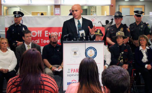
Press event at Rhode Island DMV HQ for 2012 National Teen Safe Driving Week


"photograph of the nine state program books"
Program books from Alaska, Colorado, Delaware, Idaho, Maine, Massachusetts, Nebraska, Rhode Island, and Vermont


Description of Practice

The Safe Roads Alliance worked with State department of motor vehicles (DMV) staff from around the country, highway safety researchers, academics, behavioral scientists, educators and parents and teens to develop the “best-practices” based Parent's Supervised Driving Program (PSDP). PSDP reaches out to parents of teen drivers at a critical time in the teen learning process. Currently available in 13 States, PSDP is provided to DMVs at no cost in an effort to make the most of the supervised driving period that is generally required as part of graduated driver licensing (GDL). The program includes step-by-step instructions for parents on how and what to teach their teen during the supervised driving process, including practicing in a variety of conditions and focusing on “higher order” driving skills.

Key Accomplishments and Results

Improved support and education for the parents of student drivers.

Contact

Jeff Larson
Safe Roads Alliance
617-429-9601
jeff@saferoadsalliance.org

Local Agencies in Six Louisiana Parishes Produce State's First Regional, Data-Driven Safety Action Plan

Original publication: 2013 National Roadway Safety Awards Noteworthy Practices Guide Publication FHWA-SA-14-002; 2013


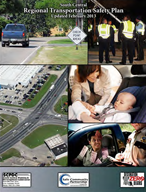
"cover of the South Central Regional Transportation Safety Plan (Updated February 2013)"
Cover of SCRTSP


Description of Practice

The South Central Regional Transportation Safety Plan (SCRTSP) is the first regional, data-driven action plan developed in Louisiana as part of the State's efforts to implement its Strategic Highway Safety Plan (SHSP). The plan is a living document that adopts and disseminates the SHSP “Destination Zero Deaths” goals and strategies down to the regional and local levels. With ongoing support from Federal, State, and local agencies, the SCRTSP uses action plans to undertake regional and local projects addressing four emphasis areas (alcohol-related driving, occupant protection, crashes involving young drivers, and infrastructure and operations).

Key Accomplishments and Results

Measured reductions in alcohol-related serious injuries as well as in serious injuries resulting from lack of seatbelt use.

Contact

Kevin Belanger
South Central Planning and Development Commission
985-851-2900
kevin@scpdc.org

Kentucky Launches Statewide High Friction Surfacing Treatment to Reduce Roadway Departure Crashes on Horizontal Curves

Original publication: 2013 National Roadway Safety Awards Noteworthy Practices Guide Publication FHWA-SA-14-002; 2013


Description of Practice

Kentucky Transportation Cabinet (KYTC) launched a three-year statewide High Friction Surfacing Treatment (HFST) program at over 75 locations in 2010 to improve pavement friction and reduce roadway departure crashes on horizontal curves. HFST was applied at specific sites where skidding crashes resulted in fatalities, serious injuries, and property damage.

Key Accomplishments and Results

There have been measured reductions in the number of roadway departure crashes on treated surfaces.

Contact

Tracy Allen Lovell, PE
Kentucky Transportation Cabinet, Division of Traffic Operations
502-782-5534
Tracy.Lovell@ky.gov