
A consistent, organized and well-communicated project identification process is needed for a successful local road safety program. The scan States have instituted policies and procedures to direct local agencies to identify projects that address their roadway safety needs and support statewide crash reduction goals. The local roadway safety projects may take many forms, range widely in cost, and include both hotspot improvements and broader systemic safety measures. This chapter describes some of the approaches to project identification used in the scan States.
Strategic Highway Safety Plans
State DOTs have developed Strategic Highway Safety Plans (SHSP), which identify the State's safety goals, priorities and strategies. Local agencies are often directed to identify projects based on the priorities established in the SHSP. Additionally, several scan States encourage low-cost treatments that can be applied systemically to address overrepresented crash types or patterns.
MDOT's HSIP process prioritizes broad systemic treatments that align with the priorities and recommendations included in the Michigan SHSP. MDOT compiles and distributes a resource list that indicates high-priority crash types, based on emphasis areas of the SHSP, and potential corridor-wide countermeasures, which are considered effective and likely to receive approval for safety funding. MDOT encourages local agencies to address locations in the State's Transparency Report and maintain consistent countermeasures throughout the roadway system. The final decision on project identification is left to the local agencies. Safety initiatives have included guardrail upgrades, signal modernizations, and corridor signal timing upgrades, which all tie into the lane departure and intersection focus areas of the Michigan SHSP.
Washington State Department of Transportation (WSDOT) reviews and updates their SHSP priorities every two years identifying priority crash types statewide. Priority crash types are identified based on fatal and serious injury crashes statewide. Roadway departure crashes have been elevated to the highest priority for remedial actions based on the most recent statewide crash data review. Once SHSP priorities are set, WSDOT conducts statewide analyses of local roadways on a county-by-county basis to identify the top fatal and severe injury crash locations. WSDOT determines the top 25 percent of counties (equivalent to 10 counties) that qualify as "above average" for a priority collision type.
County Road Safety Plans
Many local agencies would benefit from their State's assistance and guidance to assess local roadway safety and identify projects related to the SHSP goals. Minnesota developed a County Road Safety Plan (RSP) Program to help its counties identify potential safety projects. The program uses funding from traffic violations and takes a 4E (engineering, education, enforcement, emergency service) approach.
Examples of some results of Minnesota County RSP projects include edge-line rumble strips/stripes; enhanced curve delineation; intersection lighting; and dynamic warning devices.
The RSP process enables State safety specialists to work alongside county staff and other safety stakeholders to identify a prioritized list of projects. Mn/DOT, via a consultant, provides technical assistance to counties to identify local safety emphasis areas, priority strategies, and a prioritized list of safety projects. The primary objective of the RSPs is to identify a specific set of low-cost, systemic safety projects that are linked directly to the causation factors associated with the most severe crashes on the county's roadway system. Minnesota intends to implement RSPs in all counties within three years.
The RSP process increases safety awareness among local staff and stakeholders. Local agency personnel are more familiar with identifying safety issues on their roadways and suitable countermeasures to address them.
Corridor Safety Program
WSDOT instituted a Corridor Safety Program that identifies and addresses high crash corridors on the local road network.
Local agencies are often intimidated by the volumes of crash data that must be reviewed to properly identify safety issues on their roadways. Some local agencies are unsure what process to use to translate crash data for an entire jurisdiction into the development of individual safety projects. In a combined effort with the Washington Traffic Safety Commission (WTSC), WSDOT has developed a Corridor Safety Program that identifies high crash corridors on the local road network. This initiative relieves local agencies of the data analysis requirements and helps local agencies address safety issues on their roadways.
The high-incidence corridors are selected based on crash analyses showing a higher than average rate of crashes. The length of corridors for this program ranges significantly, from 3.5 to 60 miles in length. A task force is formed and site visits are conducted to identify specific safety-related issues on selected corridors. Suitable low-cost safety countermeasures are identified and implemented to improve safety on the corridor. The typical duration of review and improvement implementation on a selected corridor ranges between 18 and 24 months. WSDOT has used marketing efforts, such as branding, billboards, and websites, to publicize the projects and their safety benefits to roadway users. The Corridor Safety Program has been successful at increasing road safety in addition to building community relationships and safety awareness.
Regional Programs
New Jersey's Local Safety Program is administered via the regional MPOs.
The New Jersey Department of Transportation (NJDOT) established the Local Safety Program to provide funding for local road safety projects. Technical assistance and outreach were needed to promote this new program and educate local agencies on safety management practices. However, NJDOT recognized that they did not have the resources to support the program in this manner. Therefore, NJDOT partnered with the MPOs to identify and select local safety projects.
NJDOT regularly conducts an analysis of the crash data using a web-based crash data application, Plan4Safety, to determine areas to concentrate resources. These locations are separated into lists according to roadway characteristics and shared with the respective MPO. Each MPO is allocated a portion of HSIP funds for local road safety projects. The three New Jersey MPOs then develop programs that best meet their region's needs. North Jersey Transportation Planning Authority (NJTPA) periodically conducts a study to identify regional safety priorities, identifying potential locations for improvement based on criteria such as degree of crash exposure and geographic distribution of crashes, with a focus on county and local roads. The South Jersey Transportation Planning Organization (SJTPO) sponsors road safety audits at locations identified through a data-driven process. The Delaware Valley Regional Planning Commission (DVRPC) works with their counties to identify projects from various planning studies to advance to implementation through the Transportation Improvement Program.
MPOs can provide valuable coordination and assistance to local agencies to address regional safety priorities. The New Jersey example capitalizes on existing relationships and organizational structure, while promoting transportation safety planning that develops programs and projects to meet the goals and objectives of the region.
Visual Reference Tools
Rather than rely on local agencies to search through copious amounts of research and other sources of information on countermeasure effectiveness, Mn/DOT has developed an easily-accessible summary of preferred roadway safety treatments.
Mn/DOT created a visual reference tool, the HSIP Impact Pyramid, shown inFigure 2. The HSIP Impact Pyramid succinctly shows the relative benefits of various roadway safety measures by grouping individual countermeasures in a hierarchy of four "impact" tiers. The pyramid shows the most beneficial strategies on the largest tier (the pyramid base/foundation) and narrows to the least beneficial items on the smallest tier (the pinnacle). The HSIP Impact Pyramid reflects Mn/DOT's preference for systemic HSIP improvements that will result in the greatest impacts to local roadway safety, while acknowledging that reactive site-specific measures must also be considered. This tool has helped local agencies understand which improvements are effective, select eligible projects, and reduce crash potential on local roadways.

Figure 2: Minnesota HSIP Impact Pyramid
Source: Minnesota Department of Transportation State Aid Division
In addition, Mn/DOT uses what they refer to as the Proactive Spectrum, shown in Figure 3, in the project selection process for HSIP funding. A minimum of 70 percent of the projects awarded to each Area Transportation Partnership (ATP) are proactive; while a maximum of 30 percent of projects awarded to each ATP are reactive projects and must have a benefit/cost (B/C) ratio greater than 1.0 to be considered for funding. The Proactive Spectrum is not inclusive of all potential safety strategies. Additional strategies may be appropriate for some roadways. Minnesota created the Proactive Spectrum to help decision-makers achieve the maximum safety benefit as intended by HSIP.
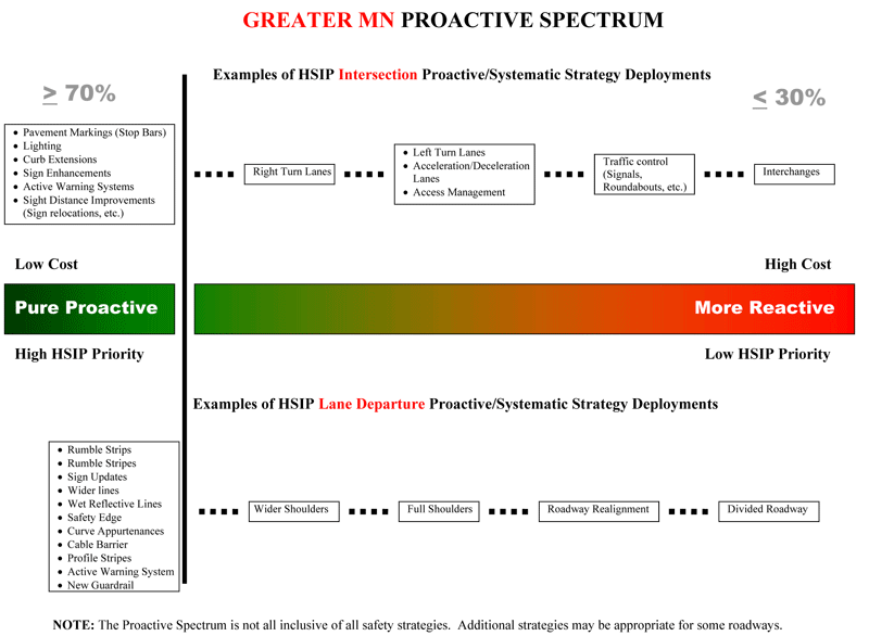
Figure 3: Minnesota Proactive Spectrum
Source: Minnesota Department of Transportation
Summary
Policies and procedures developed by the scan States have helped local transportation agencies identify systemic and site-specific improvements to improve transportation safety. Scan States have identified priorities and developed mechanisms to steer local road agency project selection processes.
In summary, practices for identifying projects on local roadways in the scan States include:
- MDOT and WSDOT focus on priorities established in the State SHSP.
- Mn/DOT develops county road safety plans that identify low-cost, systemic safety projects that are linked directly to the causation factors associated with the most severe crashes on the county's highways.
- In NJ, MPOs provide valuable coordination and assistance to local agencies in data analysis and project identification to address regional safety priorities.
- The WSDOT Corridor Safety Program identifies low-cost countermeasures to address roadway segments with safety issues. Projects are locally managed with WSDOT and WTSC assistance.
- Mn/DOT uses visual reference tools to show the impact of countermeasures and give local practitioners guidance to select both proactive and reactive projects.
- States are looking beyond individual crash sites to implement systemic improvements on corridors and roadway networks that are susceptible to overrepresented crash types.
The project identification practices discussed in this section provide resources for local transportation agencies to effectively pursue transportation safety funding and allow the State DOTs to remain involved in the review and analysis process. Productive collaboration between transportation agencies at all levels lays the groundwork for successful project identification. States must remain involved and guide local agencies through the project identification process to realize safety goals.