
Access to crash data and data analysis tools are the basis for an effective local road safety program. Crash data are used to identify locations with safety issues and assist in the prioritization of safety projects or programs competing for limited resources. However, many local agencies do not have access to crash data collected and compiled by their State or the technical training to analyze crash data and trends. As a result, local agencies with little or no access to crash data and analysis tools struggle to identify and address locations with data-driven safety needs.
To address this challenge, scan States utilize database, analysis, and mapping tools that can be easily shared with local agencies. They also provide technical assistance to aid local road practitioners in their safety analyses and countermeasure development. State assistance for local agencies in data collection and analysis can improve the ability of local agencies to develop projects and apply for funding.
Data Collection
Local agencies need access to crash data to address safety on the roads they own and operate. However, obtaining comprehensive local road crash data has presented a challenge to some States. The Illinois Department of Transportation (IDOT) recognized that limited access to crash data is a barrier to identifying safety concerns that contribute to fatal and serious injury crashes on local roads. In 2005, IDOT embarked on an innovative program to improve their local road crash database.
The Illinois Department of Transportation allocated $1 million of HSIP funds for counties to collect and geo-locate fatal and serious injury crashes on local roads.
Using HSIP funding, Illinois counties contracted for services to geo-locate five years worth of fatal and severe crash data on local roads in each county. Some counties pooled their funds and coordinated with a regional Metropolitan Planning Organization (MPO) to do the work. Other counties used temporary staff, part-time interns, or contractors to complete the work. Many local agencies recognized the significant benefits of the data and have chosen to continue collecting and geo-locating crash data using other funding sources. These crash databases have helped the counties meet the IDOT requirement for five years of data to apply for HSIP funds.
Similarly, the Michigan Department of Transportation (MDOT) funds two co-op students to geo-locate crash data in the State database. New Jersey DOT (NJDOT) also employs students to geo-locate crash data. The use of students is a cost effective means to improve crash data collection efforts.
Data Analysis Tools
All scan States either provide local agencies access to crash data analysis tools or analyze local roadway crash data for the local agencies.
Crash data analysis can be time consuming and tedious when conducted manually, requiring a large portion of limited resources. Additionally, specialized training may be required to conduct data analyses. The identification of safety issues and selection of potential projects relies on crash data analysis. Employing user-friendly crash data analysis software tools to enhance the process has resulted in greater participation of local agencies in safety programs. Without data analysis tools, local agencies are challenged to review historical crash trends; calculate crash rates and compare them to statewide rates; and determine benefits of strategies that address safety issues on the roadways they own and operate.
All scan States have either developed State-specific software tools, or use ones available from other States. These analysis tools are designed to help local agencies address roadway safety challenges by providing detailed crash information and identifying high risk locations. Scan States that provide local agencies access to data analysis software tools have shown increased interest in safety programs by these agencies. Highlights of specific data analysis tools are presented below.
Alabama
- Alabama Department of Transportation (ALDOT) utilizes the data analysis software package developed by the University of Alabama – Critical Analysis Reporting Environment (CARE).
- CARE is a free, user-friendly, statistical analysis software package designed for problem identification and countermeasure development.
- ALDOT analyzes crash data using CARE for the entire road network. A link-node internal system is utilized to review crash data to determine the average crash rates on roadways for fatalities and incapacitating injuries.
- Local agencies can access CARE once a confidentiality agreement is signed.
- CARE is web-enabled and is being integrated with GIS.
- CARE has the ability to analyze data and generate reports as well as crash diagrams.
Georgia
- Georgia Department of Transportation (GDOT) also uses the CARE statistical analysis software package to analyze crash data.
- Some of the features of the Georgia version of CARE include crash diagrams, data mining, and narrative data searching.
- GDOT manages the crash data input and the University of Alabama maintains the software.
- Access to the CARE software is controlled by GDOT, but made available to local and regional agencies through the University of Alabama's website.
Michigan
- MDOT funds and administers RoadSoft, a roadway management system with a safety component for storing and analyzing crash data.
- RoadSoft was developed by Michigan's Local Technical Assistance Program (LTAP) center.
- This software tool is available free of charge to all local agencies and provides not only a traffic crash database, but also data support for network screening, diagnostic tools, intersection analysis tools, and trend analysis.
- The output capabilities include graphical schematics with summary data, spreadsheets and tables that are used by all agencies to conduct a safety analysis.
- MDOT provides support and maintenance of the software, continually refining the data to ensure the most reliable and up-to-date information is available to agencies. MDOT has used safety funding to enhance the functionality of the safety module, including enhanced mapping, crash trend analysis, intersection collision diagrams, and new crash ranking options.
Minnesota
- The Minnesota Department of Transportation (Mn/DOT) Office of State Aid maintains the Minnesota Crash Mapping Tool (MnCMAT) system. MnCMAT provides a traffic crash database and crash analysis tools.
- All local agencies have access to MnCMAT. The output capabilities include graphical schematics with summary data, spreadsheets and tables that are used by all agencies to conduct safety analyses.
- The Minnesota Department of Public Safety provides data to Mn/DOT who maintains an internal system known as the Traffic Information System (TIS) with up-to-date crash data. The TIS data is used to populate the MnCMAT system.
New Jersey
- New Jersey Department of Transportation (NJDOT) has partnered with the Transportation Safety Resource Center (TSRC) housed at Rutgers University to develop Plan4Safety, a web-based software tool to analyze crash data in geospatial and tabular formats.
- All local agencies have access to Plan4Safety. The application allows users to quickly filter and analyze crash data and simultaneously merge specialized data sources (e.g., roadway data, EMS records) with those records for a more focused, in-depth analysis.
- Other Plan4Safety capabilities include identifying crash clusters, performing frequency analysis, generating road histograms of crash locations, calculating crash rates, diagnosing and providing national best practice countermeasures for low-cost improvements.
- The tool integrates statewide crash data and roadway characteristic data, calculates statistical analyses, incorporates network screening layers and models, and includes a visual analytical tool with accurate GIS location data.
- The GIS feature provides an interactive, visual overview of how many and what types of crashes are occurring at a given location. Satellite map views clearly show geographic details of crash sites, such as neighborhood characteristics, buildings, and intersection configurations.
- Query results are presented in automatically generated charts and tables on the output screen.
- The software also includes a module that allows users to apply for safety grants through the Governor's Office of Highway Safety.
Technical Assistance
Limited resources may deter several local road agencies from collecting crash data and conducting crash data analysis. States have developed software analysis tools that have proven more efficient in analyzing crash data. For various reasons, not all States allow local agency access to their software tools. Those that have access to the tools may require training to realize the full benefits. Scan States provide local agencies with comprehensive data collection and analysis support in multiple forms, including but not limited to: in-depth data analysis, daily fatality reports, crash maps for law enforcement and training support.
In-Depth Data Analysis
Many State DOTs have elected to conduct in-depth crash data analyses on all public roads and share these with local agencies in lieu of providing crash data analysis tools.
The Illinois Department of Transportation expanded its crash database to include local crash data and analyzes crash trends on local roadways. IDOT uses an electronic database known as Safety Data Mart (SDM) to maintain traffic crash data within the agency. Generally, crash data reports are provided to the local agencies through a request to the IDOT District Office. The SDM also provides the data for the development and distribution of the five percent report location maps and the maps that show the location of fatal and serious injury crashes. These maps are distributed for use by the IDOT District Offices and local agencies.
WSDOT identifies high crash locations and the most prevalent crash types on a county-by-county basis.
Legal barriers in the State of Washington prevent the Washington State Department of Transportation (WSDOT) from making raw crash data available to local agencies. Because crash data is not directly shared with local agencies, WSDOT conducts comprehensive data analysis for local jurisdictions on a county-by-county basis to identify high crash locations and the most prevalent crash types. The results are shared with local agencies. These types of direct technical assistance identify locations with safety issues, provide safety data for review, and aid identification of potential safety projects with little or no resource expenditure by the local agencies.
The Michigan Traffic Crash Facts website provides a yearly compilation and analysis of Michigan crash data for government agencies, the media, and the public. The data is provided by the Michigan Department of State Police from the Michigan Traffic Crash Forms (UD-10). The Michigan Traffic Crash Facts website is created and maintained by the University of Michigan Transportation Institute (UMTRI) for the Michigan State Police Office of Highway Safety Planning.
Daily Fatality Reports
Well-coordinated data analysis support between State DOTs, law enforcement and local road agencies provides a conduit for joint review and timely response to fatal crash causes. Both the Georgia DOT and Illinois DOT issue daily fatality reports to their district offices via email or web-access. In Illinois, the District Office sends a "scrubbed" version of this report to the County Engineers in which the fatal crash occurred. The District Offices work with local agencies and local law enforcement to review the need for any remedial actions.
Crash Maps for Law Enforcement
ALDOT currently develops color coded crash maps, which can be broken out by jurisdiction. As shown in Figure 1, these maps provide a visual of high crash locations color coded by segments using a link-node system. Segments show high crash locations and specify areas of severe crashes. Currently only some local roads are included in the system. ALDOT is nearing completion of a project that will update their link-node system to have the capability to reference all county roads.
These crash maps are used by several safety stakeholders including law enforcement. The police use the crash maps to develop plans to allocate manpower for traffic enforcement activity. Through the data gleaned from the maps the police can determine types of crashes, time of day and other crash attributes for selective enforcement.
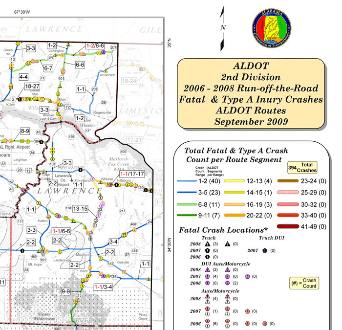
Figure 1: Example of Alabama Department of Transportation Crash Map
Source: Alabama Department of Transportation
Regional Crash Profiles
Many State DOTs often work with regional agencies to address data analysis challenges for local practitioners. In Georgia and New Jersey, the regional MPOs play an important role in bridging the gap between the State DOT and local transportation agencies. For instance, the Atlanta Regional Commission (the MPO for the Atlanta Metropolitan Area), develops crash profiles for member counties every two years. These crash profiles identify locations with high crash severity by location or victim type, including corridor, intersection, pedestrian, and bicycle locations.
In New Jersey, the North Jersey Transportation Authority (NJTPA) conducts data analyses that identify safety priorities for each county within its region. County transportation agencies review the maps to identify locations with safety issues that may be candidates for safety projects.
Training Support
In developing analytical software tools for local road agency personnel to utilize in their safety projects and programs, scan States have also recognized that training is a necessary component. To assist local agencies in understanding how RoadSoft can be used in their safety programs, MDOT sponsors multiple training sessions each year, geared toward basic, intermediate and advanced user levels. These training sessions are usually conducted by the Michigan LTAP center. The University of Alabama works with ALDOT and GDOT to provide training courses to local agencies for use of the CARE software. In New Jersey, the TSRC provides training to agencies on the use of the Plan4Safety software and its capabilities. These training courses help local agencies to fully utilize the software tools for data analysis independent of the State DOT.
Summary
Crash data is the foundation for an effective transportation safety program. Crash data is used to identify locations with safety issues and assist in the prioritization of safety projects or programs competing for limited resources. Access to a comprehensive crash database and data analysis tools are major steps in advancing with a local roadway safety program. Many State DOTs have recognized the importance of placing crash data analysis and tools in the hands of local agencies. As a result:
- IDOT uses HSIP funds to collect and geo-locate crash data on local roads. This helps local agencies support their application for safety funds.
- MDOT capitalizes on relationships with law enforcement for timely submission of crash data.
- ALDOT, GDOT, MDOT, Mn/DOT, and NJDOT utilize database, analysis, and mapping tools that are shared with local agencies. These tools are the primary means by which local agencies identify locations with critical safety issues. These State DOTs also provide local road agencies with training on the use of data analysis software tools.
- IDOT and WSDOT provide in-depth data analyses for local jurisdictions. This assistance has led to the identification of safety issues, development of safety countermeasures, and applications for safety funding to complete improvements on local roadways in the States.
- IDOT, ALDOT and GDOT provide daily fatal crash reports to local stakeholders to enable quick response to safety issues.
- MPOs in Georgia and New Jersey develop regional crash data maps or profiles that local agencies use to assess locations with safety concerns.
State assistance for local agencies in data collection and analysis improves the ability of local agencies to develop projects and apply for funding in the scan States. When State DOTs provide the means to better collect, analyze, and understand crash data, they expand and improve the ability for local agencies to make valuable decisions regarding local roadway safety. These activities provide the foundation for local agencies to identify projects that will provide the greatest benefits to transportation safety in their region.