Photo credit: Earl Walker © 123RF.com
CASE STUDY 9 – Support for Road Safety Assessments
Problem
There is a limited number of safety professionals within local agencies to analyze and address complex road safety issues.
Noteworthy Solution
Local road authorities submitted requests to Illinois DOT (IDOT) for assistance in evaluating road safety issues. IDOT’s Bureau of Safety Programs and Engineering (BSPE) provided funding and technical assistance from in-house safety specialists to conduct a large number of Road Safety Assessments (RSAs) along local road systems. The final product was a prioritized list of key findings and recommendations.
Location Prioritization and Selection
BSPE prioritized requests based on three factors (Sheehan, 2017, pers. comm):
- Number and severity of crashes.
- Support of local law enforcement.
- Level of public interest and visibility of the safety issue.
Selected sites to be evaluated through an RSA focused on identifying the locations with the potential for the largest impact on the most critical fatal and severe injury crashes. Once locations were selected, the RSAs were conducted following U.S. Federal Highway Administration’s (FHWA) guidelines (https://safety.fhwa.dot.gov/rsa/). At selected RSA sites, the BSPE assembled an independent and multidisciplinary team including IDOT, FHWA, and the Illinois State
Local public agencies participated in the RSA kick-off meetings to provide the RSA team with relevant information about the selected site. Local agencies also participated in a close-out meeting.
The RSA team answered critical questions about the selected locations, diagnosed safety issues, and identified opportunities to eliminate or mitigate the local agency’s safety concerns. The team also presented project recommendations for locations that the local agency would otherwise not have been able to address.
Examples of requests for RSA assistance approved by the BSPE included:
- A rural county skewed intersection in Iroquois County with a history of run-off-the-road nighttime crashes. Low-cost short-term safety recommendations included treatments to improve the visibility through a skewed intersection between two curvilinear roadways.
- The business extension of Interstate 55 in Bloomington. Recommendations included improving the visibility of traffic signals and minimizing or eliminating the visual clutter that exists throughout the complex visual environment along the corridor.
- The Illinois Medical District in Chicago. A combination of limited pedestrian features, overhead signal indicators, and turn lanes were contributing to an over representation of pedestrian, angle, and turning crashes. Recommended improvements included adding signal hardware with timing upgrades and adding left-turn lanes to provide more protection for pedestrians and improved intersection operation.
For all RSAs, BSPE’s technical expertise has resulted in project recommendations for key locations.
Relevant Contact
Illinois
Filiberto Sotelo
Illinois Department of Transportation
(217) 557-2563
Local Agency Action Items
Safety specialists have successfully conducted RSAs along local Illinois road systems. To obtain safety specialist support, an agency could:
- Request the state DOT or FHWA to provide additional funding, staff, and resources to conduct an RSA or similar safety analyses.
- Use safety specialists from another agency or a consultant to address complex safety issues.
- Leverage the experiences of safety specialists to identify best practices and ideas for different safety strategies that have proven successful.
References
- U.S. Federal Highway Administration (FHWA). 2014. Road Safety Audits (RSA). https://www.fhwa.dot.gov/safety/data-analysis-tools/systemic/road-safety-audits-rsa. Accessed February 11, 2018.
- Sheehan, Timothy, Safety Design Unit Chief Bureau of Safety Programs and Engineering for Illinois Department of Transportation. 2017. Personal communication with Howard Preston/CH2M HILL.
CASE STUDY 10 – Local Road Safety Plans
Problem
While local agencies support safety initiatives, they have limited experience and few resources for conducting system-wide, data-driven crash analysis.
Noteworthy Solution
The Minnesota Department of Transportation (MnDOT) pioneered new methodologies to supplement their traditional hot-spot/high-crash location analysis based on crash frequency using a systemic analysis based on crash potential. These methodologies were first described in MnDOT’s 2008 Strategic Highway Safety Plan (SHSP). North Dakota DOT (NDDOT) adapted the Minnesota process to fit North Dakota’s needs and developed a Local Road Safety Program (2013-2015). The system-wide crash analysis processes can be applied to other local agencies if their crash analysis experience and resources are limited.
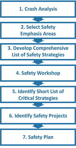
Figure 10-1. Minnesota County Roadway
Systemic Safety Planning Process

Minnesota Department of Transportation
The SHSP (MnDOT, 2008) presented four findings from the system-wide crash analysis, illustrating the importance of incorporating local road systems into broader safety planning efforts:
- Approximately 50% of severe crashes (involving a fatality or an incapacitating injury) occurred on local roads.
- Local agencies were responsible for more than 90% of Minnesota’s 140,000 miles of roads.
- Even though MnDOT’s HSIP funds were open to public roads projects, most HSIP funds were invested in the state system.
- Minnesota’s long-term vision of zero traffic deaths would be difficult to achieve if there was no investment in safety on local roads where one-half of fatal crashes occurred.
MnDOT, assisted by Minnesota’s county engineers and the U.S. Federal Highway Administration (FHWA), developed a plan to integrate local systems into its statewide safety program. MnDOT dedicated HSIP funding to exclusively support local road improvements and provided each county with technical assistance to conduct a data-driven systemic assessment and prepare a County Road Safety Plan. MnDOT’s seven-step systemic process (Figure 10-1) evaluated each county’s roadway system, based on attributes common to locations with crash histories and responses to the following three questions.
- What were the priority crash types?
- What were the priority safety strategies?
- What were the priority locations that were candidates for safety investment?
MnDOT applied the systemic safety planning process to each of Minnesota’s 87 counties. Table 10-1 summarizes the program study network for the county road system.
Table 10-1. Program Study
Network Summary
(Minnesota County Roadway System)
| Rural | Urban | |
|---|---|---|
| Roadway Miles | 27,000 | 1,600 |
| Horizontal Curves | 19,000 | N/A |
| Intersections | 13,000 | 2,900 |
Key findings from the analysis include:
- Priority crash types on rural roads were lane departure crashes (more than 50% occurred in horizontal curves and accounted for less than 5% of the system by mileage) and right-angle crashes at intersections.
- Priority crash types on urban roads were head-on/rear-end/sideswipe and right-angle and vehicle-pedestrian at intersections.
- Density of the priority crash types was very low:
- 0.01 severe road departure crashes per mile per year.
- 0.005 severe crashes per curve per year.
- 0.01 severe crashes per rural intersection per year.
- 0.02 severe right-angle crashes per urban intersection per year.
- 0.01 severe vehicle-pedestrian crashes per urban intersection per year.
- While no identified locations met the adopted state thresholds for a high-crash location, the results supported the decision to use the systemic approach to identify candidate locations with high potential for crash reduction for HSIP investments.
- High-potential locations had identified systemic crash potential factors for each rural and urban facility type. Locations with systemic crash potential factors had higher crash densities than comparable locations without systemic crash potential factors. Also, the greater the number of factors present, the higher the density of crashes. For example:
- In rural horizontal curves, the presence of an intersection in the curve and a visual trap (where the road curves but visual cues lead the driver to think the road continues straight) were identified as systemic factors (Figure 10-2). The data showed that curves with these factors had crash densities more than twice that of curves without.
- At rural intersections, the systemic factors identified included: geometry, traffic volume, commercial development, proximity to a rail grade crossing, and the distance to the previous STOP sign. Data showed that the crash density at intersections with these features was higher than at intersections without these features.
Figure 10-2. Example of a Visual Trap – Minor Road Intersects Roadway on a Curve

- The large size of the county road system combined with the low density of the priority crash types supported the development of safety projects using low-cost measures. This would allow a public agency to use its limited budget to deploy safety countermeasures at as many locations as possible. Strategies identified for Minnesota County roads include:
- Enhanced edge lines ($2,000 per mile).
- Upgraded traffic signs and markings and the installation of street lights at rural intersections (between $3,000 and $6,000 per intersection).
- Enhanced warning signs/chevrons along rural curves ($4,000 per curve).
- Edge rumbles along rural segments ($6,000 per mile).
- Red-signal enforcement lights, pedestrian countdown timers, and leading pedestrian intervals (between $1,000 and $12,000 per intersection) at urban signalized intersections.
- Road diets along urban segments ($50,000 per mile).
- More than 17,000 individual safety projects were identified with an estimated implementation cost of approximately $246 million—averaging $14,000 per project.
- To further encourage counties to submit projects for HSIP funding, a submittal form for each identified project was included in each county’s Road Safety Plan. When a county engineer requested funding for a project listed in the county’s Road Safety Plan, a copy of the submittal form was included with the local HSIP solicitation application submission.
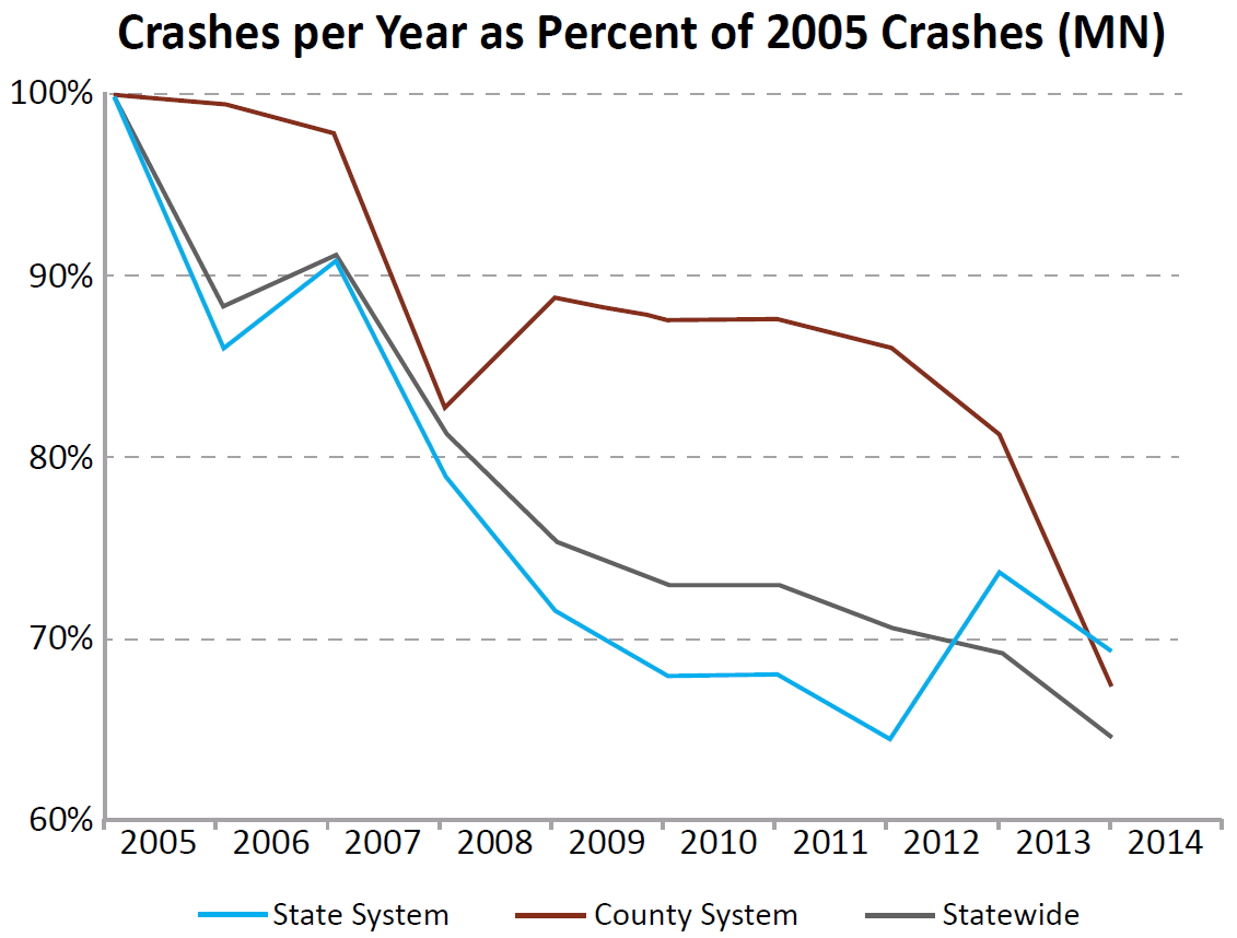
MnDOT has implemented a successful system-wide safety analysis. Since completing the County Road Safety Plan project in 2012 (MnDOT, 2018), MnDOT has met its goal of appropriating approximately $15 million per year in HSIP funds for the deployment of safety improvements throughout the county system (approximately $75 million to date). Almost 85% of Minnesota’s counties have had at least 1 safety project funded (1 county has already implemented safety projects worth more than $7 million (Vizecky, 2017, pers. comm). A recent evaluation of statewide fatalities found a 25% reduction throughout the county system since 2011 (Vizecky, 2017, pers. comm) when MnDOT first set aside HSIP funding for local system safety improvements (Figure 10-3).
Figure 10-3. Minnesota Fatality Trend Line

Source: Minnesota Roadway & Crash Data Facts 2005-2014; Adapted by FHWA
North Dakota Department of Transportation
North Dakota’s SHSP (NDDOT, 2013) highlighted the following safety facts:
- Based on crash records from 2007 to 2011, 56% of severe crashes in North Dakota (those involving a fatality or serious injury) occurred on roads operated by local agencies. Crash data between 2009 and 2013 indicated that severe crashes occurring on local roads declined to 44% (NDDOT, 2013).
- NDDOT historically used HSIP funds to support projects on the interstate, U.S. highways, and state highway systems, even though on average only slightly more than half the severe crashes occurred on these roads. Before implementing the Local Road Safety Program, less than 5% of HSIP funding was used to improve the local system—with most of this work funding the upgrade of local road approaches to intersections with state or U.S. highways (NDDOT, 2013).
In view of these findings, NDDOT committed to support goals to increase local agency participation in the statewide safety planning process and dedicated HSIP funds to improvements on local roads (NDDOT, 2013).
However, NDDOT recognized that majority of local agencies had insufficient staffing and limited experience conducting the kind of data-driven analysis required to develop HSIP-eligible safety projects.
Local Road Safety Program
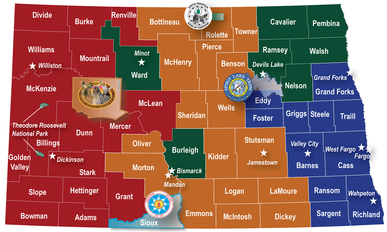
To address these concerns NDDOT initiated a Local Road Safety Program in which NDDOT partnered with local agencies to conduct a system-wide safety analysis and prepare safety plans for 53 counties, 12 major cities, 4 sovereign reservations, and 1 national park (Figure 10-4). North Dakota’s local road system encompasses more than 79,000 miles of the state’s approximately 107,000 miles. Historically, about 50% of severe crashes have occurred on local roads, but the density of these crashes was very low (0.002 severe crashes per mile per year). Prior efforts (studies, investigations, and projects) failed to identify high-crash locations along local roads based on traditional analysis methods that relied heavily on crash density. This has meant local agencies have been unable to identify HSIP-eligible safety projects.
To find out more about the high percentage of severe crashes occurring on NDDOT’s local roads, NDDOT implemented an alternative systemic assessment using road and traffic characteristics to identify, evaluate, and prioritize at-risk locations to consider for safety investment. Because this type of systemic assessment was in line with FHWA guidance, NDDOT expanded the scope of its HSIP policy—which previously only included projects identified through traditional site analysis—to include projects identified through the systemic analysis of local roads. NDDOT also determined that neither DOT staff nor local agencies had experience applying the systemic approach to safety and allocated $1.5 million to fund the systemic assessment of the local system and preparation of 70 safety plans.
Figure 10-4. North Dakota Counties, Cities, Reservations, and National Parks

Source: NDDOT, 2015
The systemic risk assessment addressed both rural and urban local roads and focused on two types of key roadway facility types: rural paved (county, tribal, and national park) and urban arterials/collectors in North Dakota’s larger cities (i.e., 5,000 population). Rural paved roads were selected for analysis based on statewide crash data that showed even though rural paved roads accounted for less than 10% of the local roads, they accounted for approximately half of all severe crashes on local roads. Further analysis indicated that on these rural roads, the most at-risk elements in severe crashes were:
- Road segments – 75% of severe crashes.
- Horizontal curves – 32% of severe crashes.
- Intersections – 20% of severe crashes.
Major cities in North Dakota (considered cities with a population of 5,000) were selected for systemic risk assessment because approximately 90% of severe crashes on local roads in urban areas occurred within the 12 cities with populations exceeding 5,000.
NDDOT used a data-driven systemic safety analysis approach to prepare the safety plans for the local agencies by identifying priority crash types and effective, low-cost safety strategies and prioritizing locations along the local road system. NDDOT prepared individual safety plans documenting the strategies that could be deployed at specific locations for each of the counties, cities, tribes, and national parks. Each plan addressed the typical barriers local agencies face when implementing HSIP projects, including:
- Linking crashes to emphasis areas.
- Conducting systemic risk analysis and prioritization of locations for implementing safety strategies.
- Identifying priority countermeasures.
- Completing HSIP project application forms.
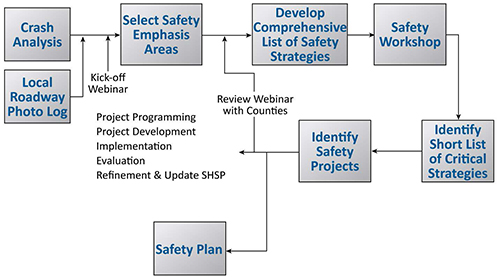
Figure 10-5. Systemic Safety Project Development Process Flow Chart

Source: NDDOT, 2015
Safety projects generated from the Local Road Safety Program (Figure 10-5) were consistent with the priorities in North Dakota’s SHSP and eligible for HSIP funding.
NDDOT considers participation in the HSIP voluntary. If local agencies choose to participate, they must:
- Submit HSIP applications.
- Agree to contribute the local share of the construction cost.
- Manage the project’s design and construction as part of their capital improvement program.
One goal for NDDOT was to identify low-cost projects that deployed safety strategies across the highest number of at-risk locations throughout North Dakota’s local road system. The local safety plans identified approximately 3,000 individual projects with a total estimated implementation cost approaching $55 million. The average project cost was around $18,000. NDDOT also looked into increasing the level of local agency engagement in the statewide safety planning process and into funding more local agency projects. The first HSIP developed after completing the Local Road Safety Program contained 15 projects submitted by local agencies (they were identified as part of the Program) valued at almost $5 million, representing approximately 35% of the Safety Program budget.
To assist local agencies when applying for funding, the safety plans included a project sheet for each project. These sheets accomplished two key objectives:
- Describe each project: the suggested strategy, the specific location where the strategy was to be implemented, the risk factors at each site, and the estimated cost of the project.
- Create an easy-to-use format for local agencies to respond to NDDOT’s annual solicitation for HSIP funding. The project sheets included information required by NDDOT staff to evaluate candidate projects for the state’s HSIP.
Feedback on the local and state levels is very positive. For local agency staff the project sheets have simplified the HSIP process. For NDDOT staff submissions using the project sheets are complete, accurate, and require no additional effort to make corrections or search for missing information.
Local Agency Action Items
MnDOT and NDDOT successfully developed safety plans using processes that can be applied by other state DOTs with less experienced staff or unused resources. Both agencies modified their SHSP process so that systemic analysis of the local roadway system could be used as a baseline for HSIP funding requests. Each agency has also prepared local road safety plans to help local agencies navigate the HSIP process and apply for local system project funding. To develop a safety plan, a local agency could:
- Collaborate with other local agencies in the region to engage the state, district, or MPO in developing a cooperative effort to conduct a systemic safety analysis.
- Request funding from state, MPO, or other sources to develop a LRSP.
- Encourage the state DOT to include a local system component and commitments in the next SHSP update.
Relevant Contacts
Minnesota
Mark Vizecky
Minnesota Department of Transportation
(651) 366-3839
North Dakota
Karin Mongeon
North Dakota Department of Transportation
(701) 328-4434
References
- Minnesota Department of Transportation (MnDOT). 2008. Strategic Highway Safety Plan.
- Minnesota Department of Transportation (MnDOT). 2014. Final Report for the Minnesota County Roadway Safety Plans. January.
- Minnesota Department of Transportation (MnDOT). Facts about Crashes, Budget, Fatality Rates. Database. http://www.dot.state.mn.us/trafficeng/publ/triviacard/. Accessed February 11, 2018.
- North Dakota Department of Transportation (NDDOT). 2013. North Dakota Strategic Highway Safety Plan. September.
- North Dakota Department of Transportation (NDDOT). 2015. North Dakota Local Road Safety Program. June.
- Vizecky, Mark, Minnesota Department of Transportation (MnDOT). 2017. Personal communication with Howard Preston/CH2M HILL.
- Minnesota Department of Transportation (MnDOT). 2018. Safety Plan Handout. http://www.dot.state.mn.us/stateaid/trafficsafety/county/tzd-handout-final.pdf. Access October 15, 2018.
