USA Banner

Official US Government Icon

Official websites use .gov
A .gov website belongs to an official government organization in the United States.

Secure Site Icon

Secure .gov websites use HTTPS
A lock ( ) or https:// means you’ve safely connected to the .gov website. Share sensitive information only on official, secure websites.

U.S. Department of Transportation U.S. Department of Transportation Icon United States Department of Transportation United States Department of Transportation

Intersection Safety

Video-Based Network-Wide Speed and Speeding Analysis, Bellevue, Washington Case Study

Summary

Speeding, exceeding the posted speed limits, or traveling too fast for conditions was a contributing factor in almost 29 percent of all fatalities in 2021. Of the 42,939 fatalities that occurred on our Nation’s roadways that year, 12,330 were speeding-related—an increase of 7.9 percent from 2020 (Stewart 2023). Speed is fundamental in dictating injury risk for all road users in any crash, especially for vulnerable road users (VRUs) such as pedestrians and bicyclists (Corben 2020).

This is one of ten case studies accompanying the Safe System Approach for Speed Management Report. Read the full report here. 

Enforcing Roadways – City of Golden, CO


Background

Prior to improvement – South Golden Road was a very wide (80 foot) street to cross and consisted of four through lanes plus a center turn lane. The corridor was capable of handling the 20,000 vehicles per day, however, the frequent points of access from business and side streets created operational and safety issues. The half-mile section of South Golden Road included two signalized intersections at Johnson Road and Ulysses Street and two stop-controlled intersections at Lunnonhaus Drive and Utah Street. The corridor was experiencing a number of issues including speeding between intersections, traffic conflicts at intersections for vehicles, pedestrians, and bicycles, and significant delays especially at Utah Street. Prior to improvement, the posted speed limit was 35 mph and the measured 85th percentile speed was 48 mph. The corridor experienced an average of four crashes per month with at least one of these involving an injury.

High Visibility Enforcement – City of Oro Valley, AZ


Background

The Oro Valley Police Department (OVPD) has created a data-driven initiative to improve traffic safety in the town of Oro Valley, Arizona. The program is called "HiVE" or High Visibility Enforcement, designed to target intersections that have high crash rates. HiVE is described as an “educational” initiative rather than a strict enforcement detail with the following two primary components:

  • OVPD publishes HiVE’s future deployment dates and times to television, print, radio, and social media. This is to alert the community about the increased visibility of law enforcement and to improve communications between the police and citizens. Partnering with local media is a key component of the HiVE
  • During scheduled deployments, OVPD places six motorcycle officers in and around the targeted intersections. Motorcycle officers actively enforce traffic violations during peak travel times. The graphic below shows the HiVE logo developed for communications and program identification.

OVPD reminds motorists not to engage in distracted driving or other driving behaviors that contribute to avoidable injury or fatal vehicle crashes.

Systemic Safety Analysis – San Diego, California

Vision Zero Success Story – Data


Background

In 2015, the City of San Diego adopted a Vision Zero approach to eliminate fatalities and serious injuries on City streets by 2025. This approach included the development and implementation of strategies in the areas of engineering, enforcement, and education. A key element of the City’s Vision Zero program was to use data to select projects with the greatest safety benefit. This data-driven philosophy was encapsulated in the City’s Systemic Safety Analysis Reporting Program (SSARP). The Safe Transportation Research and Education Center at the University of California, Berkeley assisted with the development of SSARP, which included standardizing processes to perform crash analyses, identifying safety issues, and developing a list of low-cost proven safety countermeasures. The systemic safety approach evaluated the City’s entire roadway network, rather than individual high-crash locations, and identified high-risk roadway features correlated with common crash types.

New Jersey: Roundabout Implementation Program


  • The Safety Concern: The intersection of two county roads in Burlington County, NJ had experienced severe crashes and was identified for improvements.
  • The Solution: The installation of a roundabout at the location.
  • The Result: A 100% reduction in right-angle and left-turn crashes at the location, and additional roundabout implementation elsewhere in the state.

(2017 National Roadway Safety Awards - Winner)

Virginia: VDOT’s Instant Roundabout


  • The Safety Concern: An alarming increase in crashes due to rising traffic volumes.
  • The Solution: An instant roundabout installed in less than a week using off-the-shelf products.
  • The Result: An 89% reduction in injury crashes with a solution 95% less costly than a traditional roundabout.

(2017 National Roadway Safety Awards - Winner)

US 63 Road Safety Assessment and Safety Improvements


In 2012, three at-grade intersections along US 63—a four-lane expressway in central Missouri—were identified for improvements by a multi-disciplinary team of engineers, technicians, law enforcement officers, and others who were performing Road Safety Assessments (RSA) on the route between Columbia, MO and the Iowa state border. The three intersections to be improved were those with the highest crash severity of the 11 initially studied: at Hinton Road north of Columbia in Boone County, Routes B and P near Clark in Randolph County, and Route M near Atlanta in Macon County. Among the numerous severe-injury crashes at these locations were four fatal collisions that took place prior to the sites being upgraded.

(2019 National Roadway Safety Awards - Winner)

Signage Updates Reduce Fatal Crashes in Popular Tourist/Foreign Driver Location near the Grand Canyon in Arizona


What was the safety issue, problem, or gap?

Diamond Bar Road in Mohave County, Arizona provides public road access to Grand Canyon West, site of the internationally renowned Grand Canyon Skywalk on the Hualapai Indian Reservation, attracting approximately 700,000 visitors annually. Subsequent to Diamond Bar Road reconstruction by the Hualapai Tribe and Bureau of Indian Affairs, two (2) fatal, head-on crashes occurred on the facility, approximately 0.7 miles from its intersection with Pierce Ferry Road, which provides access to U.S. 93 and Interstate 40 servicing Grand Canyon West visitor traffic. Each crash involved unimpaired drivers from Ireland and Australia who encroached into the opposing lane of travel upon negotiating the first horizontal curve encountered on Diamond Bar Road.

What were the key challenges that needed to be addressed before the new practice could be implemented?

The key factors focused on identifying the unique driver experiences relating to the crashes and crash circumstances including:

  • Inexperience in driving United States roads with oncoming traffic passing on the driver's side, and
  • Driver behavior as a tourist subject to acute distractions such as scenery, communication with other vehicle occupants, and/or reading directions/maps.

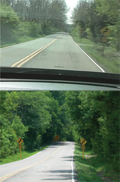
The County's Engineering Division performed a detailed field investigation and traffic engineering report based on intensive two-day observations of inbound tourist traffic to Grand Canyon West during the active holiday season. It found—in seven hours' time over two morning ingress periods—30 separate instances of drivers stopping in the road, backing, making a U-turn, or turning/entering into the opposite lane of travel before immediately correcting. Figure 1 indicates example traffic maneuvers witnessed during the investigation.

"satellite image of the intersection labeled with observed, unsafe traffic manuevers"

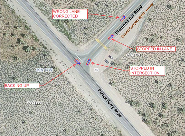
Figure 1. Example Vehicle Maneuvers Substantiating Tourist Driver Behavior

Describe the new practice.

The Mohave County Traffic Safety Committee reviewed and endorsed the traffic engineering study findings and recommendations, and the County subsequently installed the following devices in January 2013:

  • An oversize 48” x 48” W6-3 Two-Way Traffic Warning Sign installed on both sides of Diamond Bar Road facing traffic entering Diamond Bar Road.
  • A white thermoplastic through arrow in both Diamond Bar Road travel lanes adjacent the warning signs.
  • Total expense including material and labor costs at the County's burdened rate is $871.00.

Key accomplishments, including roadway safety improvements

January 2015 marks two full years Mohave County has maintained its Wrong-Way Driver Warning Devices. Its success is attributed to zero crashes post-improvement throughout the 14-mile Diamond Bar Road relative to crash type and crash causal factors attributed to the two fatal crashes prompting this Mohave County safety project.

What benefits were realized as a result of the practice?

The devices take a low-tech form but directly address human factors based needs identified in the County's traffic engineering study driving device identification and implementation.

Contact

Michael P. Hendrix, P.E., County Administrator
3715 Sunshine Dr.
Kingman, AZ 86409
928-757-0910

Ohio DOT and LTAP Provides Opportunities for Townships to Improve Town-wide and Corridor Signage at Intersections and Curves

Summary from Assessment of Local Road Safety Funding, Training, and Technical Assistance: Benefit/Cost Tool and Local Road Safety Manual


Background

The Ohio DOT's (ODOT) Office of Local Programs, with the assistance of the Ohio Local Technical Assistance Program (LTAP) Center, administers a systemic signage intersection and curve upgrade program for targeted Ohio Townships. The program provides two opportunities for townships to apply for free safety and advanced warning signs.

  • The Township-wide Systematic Signage Upgrade Program is for Townships with a high number of severe crashes. The Top 50 Townships with a high number of serious crashes for a five-year period are invited to apply for funding to implement systematic signage upgrades.
  • The Township Corridor Systematic Signage Upgrade Program provides intersection signage and curve upgrades for Townships with a corridor among the Top 50 Township High-Risk Rural Roads in Ohio based on a five-year period of crash data. Townships can apply for funding on designated corridors.
  • Townships participating in the programs are responsible for installation and maintenance of the signage and are limited to a list of preapproved signs.

As a part of the program, the Ohio LTAP Center provides crash data and information on the types of sign packages available for specific situations. Townships can choose from the signage packages or build their own sign orders. The ODOT Office of Local Programs also provides guidance and assistance to Townships on sign installation if necessary. Program details are available on the ODOT Local Programs web page.

Figure 1. Before and After Photos of Sign Installation Completed as Part of Program.

"two photos of the same stretch of paved road, surrounded by trees on both sides: the top photo shows one yellow 'S'/30 MPH caution sign on the right side of the road; the bottom photo shows one on each side of the road and a third, large caution sign in the distance where the road begins to curve"
Source: Ohio Department of Transportation/LTAP


Benefit

The signage packages help insure the townships install the signs according to the requirements of the Ohio Manual of Uniform Traffic Control Devices (OMUTCD).

Contact

FHWA Office of Safety staff contacts by safety function