USA Banner

Official US Government Icon

Official websites use .gov
A .gov website belongs to an official government organization in the United States.

Secure Site Icon

Secure .gov websites use HTTPS
A lock ( ) or https:// means you’ve safely connected to the .gov website. Share sensitive information only on official, secure websites.

U.S. Department of Transportation U.S. Department of Transportation Icon United States Department of Transportation United States Department of Transportation

Safety Data

Ohio, with Stakeholder Input, Develops Consistent Mapping and Data Standards for State and Local Roads

Summary from: Ohio Location Based Response System State and Local Data Integration Case Study FHWA-SA-14-036


Background

This case study, available as part of the Federal Highway Administration's (FHWA) Integration of State and Local Safety Data project, describes Ohio's efforts to integrate local roadway data into their State data system.

This case study is part of a series of four. Each case study identifies a State's experience collecting local data, the challenges and obstacles faced and how they were overcome, benefits of the practices, reasons for success, lessons learned, and applicability of the practices to other agencies.

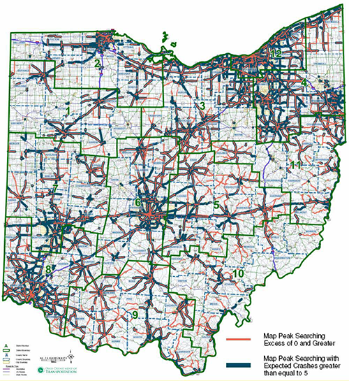
With the majority of public road mileage in Ohio owned and maintained by local agencies such as counties, cities and villages, ODOT (Ohio Department of Transportation) faced challenges with consistency in creating and storing local road maps: there was no single standard and locating crashes on local roads was a “hit or miss” process. For the most part, local road jurisdictions did not have a consistent linear referencing system—many local roadway crash reports referenced approximate street addresses, alias street names, or intersections that no longer existed. Using street addresses as a location reference was problematic because the State road database did not contain address ranges, and the State's list of local street names was often inaccurate. Given that roughly two-thirds of crashes in Ohio happened on non-State roads, this was a significant concern.

To remedy the issue, Ohio integrated the local road system into the State Linear Referencing System (LRS) by assigning consistent route numbers and mileposts to the local roads and then brought the local roadway data into a centralized data system: the Location Based Response System (LBRS). With data standards set by ODOT, each local agency collects, inputs, and field verifies the data in LBRS. LBRS is web-based and the information is available for all stakeholders as soon as agencies enter it. Mapping and analytic tools are available through the website.

Key Accomplishments:

The following are key accomplishments of the Ohio Location Based Response System:

  • Improved location references for crashes on local roads.
  • Consistent mapping and data standards.
  • Easy integration of compliant local data into the State roadway database.
  • More efficient process for conducting safety analyses.
  • Routine updates of State road miles and addressing.
  • Improved data access for the State and local agencies.

Results:

The integration of local and State data via the LBRS proved beneficial for a number of State agencies, as well as the local agencies themselves. At the State level, the improved road centerline and mileposting data has enhanced crash reporting and safety analysis. Ohio now places local road crashes more accurately allowing for better analysis of road safety issues in the counties. The State also now has consistent mapping and data standards for all counties allowing easy integration and improved data access. Finally, this program helps save taxpayer dollars by reducing redundant, and sometimes conflicting, data collection activities. At the local level, one of the most important uses of the LBRS data is for better routing for 911 services by providing more accurate location information for 911 calls and support for next generation 911 implementation.

Ohio plans to improve integration by providing more guidance to local agencies on data maintenance and increasing coordinated communication among the State and local agencies. However, Ohio's experience so far with developing and implementing LBRS shows that there can be successful integration of the local road addressing and mileposting into a State system.

Contacts

Stuart Davis
State CIO/Assistant Director
Ohio Office of Information Technology
614-644-3923
Stu.Davis@oit.ohio.gov

Jeff Smith
GIS Administrator
Ohio Office of Information Technology
614-466-8862
Jeff.Smith@das.ohio.gov

Dave Blackstone
GIS Manager
Ohio Department of Transportation
614-466-2594
Dave.Blackstone@dot.State.oh.us

Stuart Thompson
Federal Highway Administration
202-366-8090
Stuart.Thompson@dot.gov

Michigan's Roadsoft Program Enables Local Agencies to Collect and Maintain Data, while Preserving Local Ownership and Control

Summary from Michigan Roadsoft Integration of State And Local Safety Data


Background

This case study, available as part of the Federal Highway Administration's (FHWA) Integration of State and Local Safety Data project, describes Michigan's efforts to integrate local roadway data into their State data system.

This case study is part of a series of four. Each case study identifies a State's experience collecting local data, the challenges and obstacles faced and how they were overcome, benefits of the practices, reasons for success, lessons learned, and applicability of the practices to other agencies.

One way some States are enabling local agencies to collect and maintain data, while still preserving local ownership and control, is through centrally supported data models like Michigan's Roadsoft program. With Roadsoft, there is no centralized database of local data; local agencies receive a copy of the Roadsoft software to download and maintain locally. However, since Michigan applied a consistent linear referencing system to the local roads, and since most local agencies use the Roadsoft system, the similar structure and data definitions make it easier to share data when needed.

Michigan Technological University's Center for Technology and Training (CTT) developed Roadsoft for the Michigan Department of Transportation (MDOT) as a standardized suite of data management and analysis tools in the early 1990s for local centerline mileage certification and pavement management. Before Roadsoft, local agencies had widely varied levels of access to IT support, software tools and analytic capability. Over time, MDOT and the CTT enhanced Roadsoft to cover a broader range of assets and planning and budgeting support, and to include features such as traffic and crash data for use in safety analysis.

The Roadsoft system meets most analysis needs at the local agency level, but more advanced analyses are not included in Roadsoft. To do such analyses, the local agency must create a data extract to import into any other analysis package. With funding from MDOT, the CTT also supports local agencies with training and analytic assistance. Local agencies are not required to use Roadsoft, though approximately two-thirds of local agencies do.

While MDOT provides Roadsoft to local agencies at no charge, it does not eliminate the costs of data collection. Still, Roadsoft does improve data quality by defining data collection standards, where applicable, within each module. Local agencies are only required to report standard roadway asset and pavement condition data to MDOT for the Federal aid-eligible portions of their network; however, the same standards apply to all data entered into the system. Additionally, Roadsoft has modules for managing a large number of assets and each module was created based on input from local agencies. To help with data collection, Roadsoft has an integrated, GPS-enabled, mobile data collection utility which links Google Maps and Street View, thus creating an inexpensive photo log.

Key Accomplishments:

The following are key accomplishments of Michigan's Roadsoft system:

  • Improved location references for crashes on local roads.
  • Consistent mapping and data standards for all local jurisdictions.
  • Data sharing among local, regional, and State agencies.
  • Efficient process for conducting safety analyses.
  • Comprehensive asset management capabilities.

Results:

The lessons learned from the Roadsoft effort are that long-term support, local agency control, and frequent, gradual, incremental updates, are the keys to Roadsoft's success. The CTT supports the incremental nature of Roadsoft development using a rapid prototyping model with frequent user testing to be sure that the final product meets local users' needs. Local users have a great deal of control over decisions regarding Roadsoft's enhancements—the Roadsoft Users' Group selects and approves each project. MDOT supports Roadsoft by funding the CTT's efforts and by supplying data.

Contacts

Tim Colling, Director
Center for Technology & Training (CTT)
Michigan Technological University
906-487-2102
TKCollin@mtu.edu

Stuart Thompson
Federal Highway Administration
202-366-8090
Stuart.Thompson@dot.gov

Idaho Uses Highway Safety Manual Methodology to Identify Priority Locations for Safety Improvements

Original publication: National Roadway Safety Awards: Noteworthy Practices Guide; 2013

Download latest Adobe® Reader


Description of Practice

To improve cost effectiveness in funding safety projects, Idaho Transportation Department used an innovative, data-driven program for safety analysis on roadways throughout the State. The project includes assessing 5 years of statewide crash records, diagnosing the priority locations to determine casual relationships between site characteristics and crash records, identifying recommended improvements, and conducting benefit-cost analysis to rank the recommended safety improvements.

Key Accomplishments and Results:

  • Utilization of the Highway Safety Manual (HSM) methodology to identify the highest priority locations for safety improvements
  • List of ranked safety improvement projects reflecting the most effective use of funding for safety projects

"Map showing the priority corridor identified by the data"

Contact

Brent Jennings
Idaho Transportation Department Office of Highway Safety
208-334-8557
Brent.Jennings@itd.idaho.gov

Florida Uses Predictive Methods found in the Highway Safety Manual (HSM) for Alternative Selection in Florida (HSM Case Study 3)

Original publication: Highway Safety Manual Case Study 3: Using Predictive Methods for Alternative Selection in Florida


Background

The American Association of State Highway and Transportation Officials' (AASHTO's) Highway Safety Manual Part C Predictive Method (Chapters 10-12) estimates crash frequency and severity. The predictive method uses equations known as Safety Performance Functions (SPFs) to estimate the predicted average crash frequency as a function of traffic volume and roadway characteristics (e.g., number of lanes, median width, intersection control, etc.). The HSM provides SPFs for rural two-lane, two-way roads; rural multilane highways; and urban and suburban arterials. The predictive method enables informed decision making throughout the project development process, including the selection of alternative roadway designs.

Key Accomplishments

Florida DOT (FDOT) District 7 (Tampa area) volunteered to analyze corridor widening project alternatives on State Road (SR) 574 using the HSM predictive method. FDOT used the predictive method for urban and suburban arterials (Chapter 12) to evaluate the predicted safety performance of each alternative over a 20-year horizon. They used the urban arterial SPFs (refer to HSM equation and tables) and adjusted for the proposed geometric conditions based on the crash modification factors (CMFs) for median width provided in the HSM (Table 12-22).

Results

Based on these results, a four-lane divided alternative was predicted to have a crash cost savings of approximately $4.2 million compared to a five-lane with two-way left-turn lane alternative. A benefit-cost ratio was calculated by dividing the crash cost savings by the difference in right-of-way (ROW) costs.1 The resulting benefit-cost ratio was equal to 2.64, illustrating that the benefit obtained through improvement in crash costs more than offset the differential in ROW costs. The results of this analysis were used to justify the additional ROW costs of the four-lane divided section.

The HSM predictive method enables the design engineer to estimate quantitative safety impacts of various design alternatives and provide justification for their design decisions. For the SR 574 study in particular, the loss of parking at the post office necessary to construct the four-lane divided section, may have been difficult to justify to the post office and the public based on engineering judgment alone. However, the use of the predictive method provided the design engineer with quantifiable evidence on why the four-lane alternative is preferred based on the crash cost savings.


1 Although there are differences in costs associated with construction, ROW was found to have the most significant impact, and therefore, ROW was the only cost considered in the economic analysis.

"Highway Safety Manual logo"

Contact

David O'Hagan
Florida Department of Transportation
(850) 414-4283
David.OHagan@dot.state.fl.us


Florida Highway Patrol Piloting Signal Four Analytics, a Web-based Crash Mapping and Analysis Tool

Original publication: Signal Four Analytics, a Web-based Crash Mapping and Analysis Tool – Florida Highway Patrol(Website)


Key Accomplishments

Traffic crash data is available now in greater detail than ever, but making sense of this data remains a challenge to law enforcement, transportation planners, and traffic engineers. These professionals need powerful, accessible, and affordable tools to explore the spatial and logical relationships that drive decisions on resource allocation and project prioritization. Signal Four Analytics aims to address these needs by providing current crash and streets data paired with interactive analysis and visualization tools, accessible via any modern web browser.

Results

Florida Highway Patrol (FHP) is currently the statewide pilot agency for this system. The GeoPlan Center and FHP are working together to ensure that the system will fulfill the crash analysis needs of law enforcement for identifying critical safety areas in order to apply enforcement education countermeasures effectively to reduce fatalities and injuries on Florida's roadways.

Crash data—long and short form, collected electronically by FHP officers at crash sites throughout the state—is transmitted nightly to the GeoPlan Center and loaded into the Signal Four Analytics database. Live database statistics are shown above and to the right.

Once the pilot phase is complete, Signal Four Analytics will be extended for use to interested traffic engineering, transportation planning, and other law enforcement agencies in Florida.

"Screenshot of the Signal Four Analytics Tool"

Figure 1. Signal Four Analytics Web Interface

"Two enlarged screenshots from the Signal Four Analytics Tool, the first showing data on a map as individual points, and the second showing the same data as clusters"

Figure 2. Crash data can be viewed spatially in the context of a map. The system can present the data as individual points, or collectively as clusters. The map views allow analysts to quickly gain an intuitive understanding of the spatial distribution of crashes.

Figure 3. Crash attributes and derived statistics can be viewed in tabular format. Tables interact with the map view—as records are selected, associated points are highlighted on the map (and vice-versa).

"Screenshot from the Signal Analytics Tool, showing a horizontal bar chart of the distribution of crashes by day of the week"

Figure 4. The distribution of crashes can be charted according to any number of attributes (day of week, for example).

Contact

Major Richard S. Mechlin
Office of Strategic Services, Florida Highway Patrol
2900 Apalachee Parkway, MS-43
Tallahassee, FL 32399
850-617-2377
richardmechlin@flhsmv.gov

Dr. Ilir Bejleri
954-214-7885
Ilir@ufl.edu

Ohio DOT Implements New Roadway Safety Management Process with AASHTOWare SafetyAnalyst™

Original publication: Highway Safety Manual Case Study 2: Implementing a New Roadway Safety Management Process with AASHTOWare Safety Analyst™ in Ohio


ODOT's use of AASHTOWare Safety Analyst™ (SA) allowed it to develop multiple screening methods in the network screening process resulting in greater identification of rural corridors and projects.

Issue

Application of the Highway Safety Manual (HSM) and related safety data tools.

Key Accomplishments

“Ohio DOT is excited about the opportunities that SA provides the highway safety engineering community by allowing the end users to easily perform network screenings and countermeasure evaluations with a high level of statistical rigor.”

– Jonathan Hughes, ODOT

  • Establishing a process that advances the capacity to perform roadway safety analysis while also shortening the time needed to conduct the analysis.
  • Improving data collection and data quality.
  • Working with IT staff (a crucial step) to ensure hardware and software needs were met in all offices.

Results

Applying various HSM screening methods identified ways to overcome some of the limitations of existing practices. For example, the agency's previous mainframe methodology typically over-emphasized urban “sites of promise,” or those locations identified for further investigation and potential countermeasure implementation.

Benefits

  • The extensive data gathering effort increased output reliability, allowing the agency to direct safety funds to locations where transportation improvements have the greatest potential to reduce severe (fatal and injury) crashes.
  • A big advantage of AASHTOWare Safety Analyst™—in comparison to the previous mainframe process—is the ability to quickly apply the more sophisticated screening methods within the HSM.
"map of Ohio with highway segments colored to show expected and excess crashes"
Figure 1: GIS Display of Expected and Excess Crashes for Highway Segments


Contact

Jonathan Hughes, P.E.
Ohio Department of Transportation
(614) 466-4019
Jonathan.Hughes@dot.state.oh.us

Idaho Uses Predictive Methods in IHSDM to Evaluate Safety in Idaho 8 Corridor

Original publication: Highway Safety Manual Case Study 1: Using Predictive Methods for a Corridor Study in Idaho


Idaho used FHWA's Interactive Highway Safety Design Model (IHSDM) along the Idaho 8 corridor to evaluate existing traffic, roadway geometry, and predict crashes using these and the corridor's recent crash history.

Issue

Application of the Highway Safety Manual (HSM) and related safety data tools.

Key Accomplishments

“The advantage of employing IHSDM on this project was the opportunity to perform a detailed and simultaneous review within the corridor on a variety of critical elements (that is, traffic operations, geometry, safety) to isolate potential problem areas and allow development of strategic mitigation strategies.”

– Bob Beckman, Project Manager

  • FHWA's Interactive Highway Safety Design Model was used to evaluate the safety and operational effects of existing traffic and roadway geometry on highways. This evaluation, along with the corridor's recent crash history, was used to predict crashes.
  • While the IHSDM is a data intensive program, the time and effort invested in data entry is rewarded through the production of a detailed quantitative safety analysis.

Results

The development of a more advanced safety analysis for the Corridor Study that was data-driven and integrated into the Statewide Transportation Improvement Program (STIP).

Benefits

  • The IHSDM Policy Review and Crash Prediction modules were very useful in identifying existing geometric deficiencies, specific locations needing further evaluation, locations needing possible design improvements, and potential safety issues in the corridor.
  • A Corridor Plan Report was prepared to document the review, analysis, and resulting recommendations of this study to be included in the STIP for future implementation.

"Photograph of a section of Idaho's Highway 8"

Figure 1: Idaho 8 Corridor

"map showing the area of Highway 8 in the Corridor study"

Figure 2: Idaho 8 Corridor Map

Contact

Ken Helm Senior Transportation Planner
Idaho Transportation Department
(208) 799-4229
ken.helm@itd.idaho.gov

Ohio Develops Centralized Data Source for All SHSP Partners

Original publication: SHSP Implementation Process Model, Supplement Number 1 – Case Studies; FHWA-SA-10-025; 2010(PDF, 1MB)


Key Accomplishments

  • Developed a centralized data source for all SHSP partners resulting in more consistent safety analysis Statewide.
  • Established common data analysis processes enabling problem identification, tracking, and evaluation to be conducted in a consistent manner across agencies.
  • Improved local agency and MPO safety analysis capabilities by providing user-friendly analysis tools.

The SHSP process requires data from a variety of sources to support the emphasis areas. If a central data source is not available, emphasis area teams may use conflicting data. When the safety data used by multiple agencies is inconsistent, tracking, evaluation, and problem identification are difficult.

To improve data consistency, Ohio created the Crash Statistics System (CSS), a single Statewide crash database for use by all agencies and the public. The CSS is managed by the Department of Public Safety (DPS), which is also responsible for license, citation, and vehicle registration data. The Ohio Enhanced Crash Location and Identification System (OECLIS), managed by the Ohio Department of Transportation (ODOT), uses the latest three years of crash data, which are merged with data on roadway characteristics and then analyzed to identify high-crash intersections and corridors. These databases support development of SHSP strategies and action plans.

A second element developed by ODOT, the GIS Crash Analysis Tool (GCAT), is an on-line GIS Web tool designed to enhance safety analysis capabilities. It allows users to extract crash data spatially and to create tables, charts, graphs, and collision diagrams based on the crash data selected from the map. The Crash Analysis Module (CAM) Tool is an Excel template that was built for the GCAT and helps facilitate common data analyses and queries, including crashes by day-of-week, light condition, weather condition, severity, and road condition.

State and local law enforcement agencies provide funds for data collection. ODOT staff cleans and maintains the data and provides data analysis support for metropolitan planning organizations (MPO) and local agencies. Ohio used §408 funds to develop the CSS portal.

Results

Ohio’s centralized process for safety data distribution has resulted in improved consistency in data analysis among all SHSP partners. Problem identification, tracking, and evaluation of safety progress have improved. The CSS, GCAT, and CAM Tool have increased local government and MPO access to crash data and enabled agencies to easily perform basic crash analyses.

Contact:
Jonathan Hughes, P.E.
Office of Systems Planning and Program Management
Ohio DOT
614-466-4019
jonathan.hughes@dot.state.oh.us

Michigan DOT Uses MOU to Define Roles Among Data Generators

Original publication: SHSP Implementation Process Model, Supplement Number 1 – Case Studies; FHWA-SA-10-025; 2010(PDF, 1MB)


Key Accomplishments

  • Developed an MOU to clearly define roles, responsibilities, and funding obligations related to crash data management.
  • Improved data quality and timeliness.
  • Ensured consistent use of data Statewide through uniform data queries.

The Michigan DOT (MDOT), Department of State, and State Police signed a memorandum of understanding (MOU) defining crash data management and funding. The State agencies invested in a team of three people, including a dedicated project manager, over a five-year period. The MOU provided a basis for ongoing cooperation and communication concerning Michigan’s data systems. Researchers can review current data without personal identifiers within 24 hours of receiving crash reports. The Michigan Office of Highway Safety Planning (OHSP) provides funding for a research center at Wayne State University, which provides public access to annual reports on safety data.

The State’s safety stakeholders understand they all need to be working with the same data and statistics for each crash type; therefore, a uniform data query was developed for Statewide use to ensure consistency in the number of crashes for each emphasis area and other crash types.

Michigan currently is transitioning to electronic crash reporting and citation management to reduce reporting errors. Paper crash reports have an average of 1.5 errors per form, while the error rate for electronic crash reports is very low given the quality checks that can be implemented (e.g., it is impossible to enter conflicting data such as the weather was sunny and the crash occurred at midnight). The OHSP contributed $1 million in funding in 2007 for electronic crash reporting equipment. One county currently operates a completely paperless system. Citation information is processed quickly; therefore, in areas with electronic data processes, a person can drive directly to the courthouse to pay the fine after receiving a citation.

Results

The State established a uniform crash reporting system with improved data quality, reliability, and timeliness. Data are now widely available to all potential users to improve safety data analysis and dissemination.

Contact:
Dale Lighthizer
Supervising Engineer
Michigan DOT
517-373-2334
lighthizerd@michigan.gov

SHSP Committee Provides Forum for Data Collection Improvements

Original publication: SHSP Implementation Process Model, Supplement Number 1 – Case Studies; FHWA-SA-10-025; 2010(PDF, 1MB)


Key Accomplishments

  • Used collaborative process of the TRCC to conduct problem solving related to data quality.
  • Improved quality of commercial vehicle safety data resulting in the receipt of MCSAP funding.
  • Implemented improvements in one of the key SHSP emphasis areas.

Since data is the foundation of transportation safety planning, the Ohio Department of Transportation identified data improvement as one of the priority emphasis areas in its SHSP. Each year the Federal Motor Carrier Safety Administration (FMCSA) publishes a State-by-State safety data quality rating that summarizes the completeness, timeliness, accuracy, and consistency of State-reported commercial motor vehicle crash and inspection records. States receive either a poor, a fair, or a good rating. Ohio received a “fair” rating and wanted to improve its “timeliness” rating to receive Motor Carrier Safety Assistance Program (MCSAP) incentive funds.

Ohio’s TRCC is responsible for overseeing data improvements included in the SHSP. The TRCC is the perfect forum for addressing this issue since all the necessary partners are members of the committee. Ohio’s Department of Public Safety (DPS), which provides motor carrier crash data to the FMCSA, did not realize that by not meeting the Federal data reporting deadline, the State was being penalized. Through its participation in Traffic Records Coordinating Committee (TRCC) meetings, DPS learned of this problem and was able to modify its data reporting process to accommodate the deadline. The policy changes involved the department obtaining crash data from local governments in a timelier manner to meet FMCSAs data reporting requirements.

Results

By improving the timeliness of its data reporting, and therefore its safety data quality rating, Ohio received several hundred thousand dollars in MCSAP incentive funds.

Contact:
Tom Hollingsworth
Chief, Traffic Statistics
Ohio Department of Public Safety
614-387-2800
THollingsworth@dps.state.oh.us