Publication Year: 2017
Background
The Ohio Department of Transportation (ODOT) uses a data-driven approach to identify, screen, and prioritize potential highway safety improvement projects. ODOT analyzes crash, roadway, and traffic data to identify sites with potential for safety improvement. Typically, ODOT studies up to 300 locations annually across the State. ODOT District offices and local agencies diagnose safety issues at these locations and develop targeted countermeasures to address the underlying crash contributing factors. The District offices develop funding applications for safety projects and submit the applications to the Central Office for further consideration. Multidisciplinary committees review and evaluate the project applications based on factors such as crash analysis; statewide, regional or local priority; matching funds; and benefit-cost analysis.
Each year, ODOT reviews approximately 70 applications for safety improvement projects. While ODOT spends more than $100 million annually on highway safety improvement projects, the funding requests total more than $150 million. As such, there is a need to prioritize those projects with the greatest potential for reducing crashes.
Solution
To support the highway safety project prioritization process, ODOT developed the Economic Crash Analysis Tool (ECAT). ECAT supports analysts in estimating the safety performance of a given facility (existing or proposed), conducting alternatives analyses, and completing a benefit-cost analysis. This tool automates much of the analysis, simplifying the process and allowing people with various skill levels to use the tool and make better safety investments.
In developing ECAT, ODOT reviewed available spreadsheets such as those developed for the implementation of the Highway Safety Manual (HSM). This provided the foundation for the underlying safety performance calculations. To simplify the process, ODOT combined multiple HSM-related spreadsheets into a single spreadsheet.
Using ECAT for benefit-cost analysis, the user selects the site type and enters basic project information such as costs and safety benefits. The user can specify various costs, including the initial construction cost, operating and maintenance costs, and salvage value. Analysts use other supporting modules in ECAT to estimate the safety benefits in terms of change in predicted and expected crashes. The tool provides default values for inputs such as the projected service life. Based on the user inputs for costs and benefits, the tool computes the present value costs and benefits based on a discount rate of 4.0 percent.
The following figures provide examples of outputs from the benefit-cost analysis module in the ECAT tool. Figure 1 shows an example of the economic analysis summary table from ECAT, which indicates the net present value of the project (i.e., present value cost), the net present value of safety benefits (i.e., present value benefit), net benefit (i.e., present value benefit minus present value cost), and benefit-cost ratio (i.e., present value benefit divided by present value cost). The summary table also indicates the expected annual crash adjustment in terms of the change in the number of fatal and incapacitating injury crashes, change in the number of all injury crashes, and the change in total crashes.
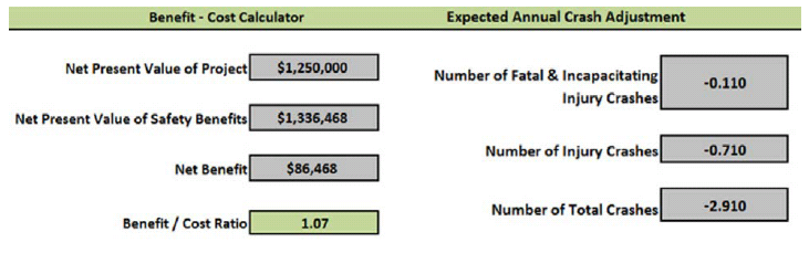
Figure 1. Sample economic analysis summary tables from ECAT.
Figure 2 shows an example of the economic analysis summary charts from ECAT. The upper left chart presents a summary of the combined projected cash flows by countermeasure by year. Negative cash flows represent an expenditure (greater investment than return) and positive cash flows represent a return on investment. The middle chart presents a summary of cash flows by year for project costs only. This example shows an initial project cost in year 0, and either maintenance or rehabilitation costs in years 5, 10, and 15. The bottom right chart shows the return on investment (i.e., cumulative annual benefits minus cumulative annual cost). Users can quickly identify the breakeven year as the first year with a positive return on investment. In this example, the breakeven year is year 8.
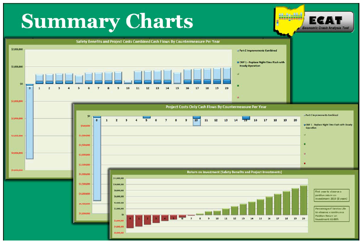
Figure 2. Sample economic analysis summary charts from ECAT.
Sources
Traffic Academy Safety Studies & Freeway Safety Study Guidelines
Ohio Department of Transportation, 2017
Highway Safety Manual
Ohio Department of Transportation
Division of Planning
Office of Systems Planning and Program Management, February 2017
Contact
Tim McDonald
Ohio Department of Transportation
Office of Planning
Tim.Mcdonald@dot.ohio.gov
(614) 466-4019
Resources
ODOT requires the use of ECAT for all safety studies completed on the State highway system. To support users, ODOT posts examples and help files along with the tool on the ODOT Highway Safety Improvement Program website. ODOT posts enhancements and updates to the tool with release notes documenting changes.
The tool and supporting documentation are available from the Office of Systems Planning and Program Management, Highway Safety Manual Data Analysis Tools webpage. (This page is no longer available.)